Do you have a question about the Garmin GPS 72 and is the answer not in the manual?
Provides safety warnings for vehicle use and general cautions for product operation.
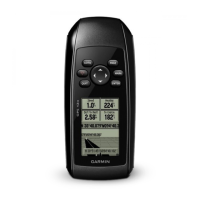
Outlines the key specifications and functionalities of the GPS 72 receiver.
An index listing common procedures and their corresponding page numbers for quick reference.
Explains the essential first-time setup and satellite acquisition process for the GPS receiver.
Details the data displayed on the GPS Information Page, including status and satellite reception.
Describes the Map Page functionality, including zoom control and display options for map data.
Explains the Pointer Page, used for navigation when a straight course is not feasible.
Details the Highway Page, designed for road navigation and turn-by-turn guidance.
Describes the Main Menu structure and access to various features like Trip Computer and Points.
Provides step-by-step instructions on how to create new waypoints using different methods.
Explains the concept of routes, how to create them, and manage existing routes.
Guides users on how to navigate to saved waypoints, points of interest, or cities.
Details information on Tides, Sun and Moon, and Hunt and Fish times.
Configures basic settings like receiver mode, WAAS, backlight, beeper, and language.
Sets location parameters including format, map datum, north reference, and magnetic variation.
Configures various alarms such as Anchor Drag, Approach/Arrival, and Off Course.
Lists the physical dimensions, weight, display, and performance metrics of the GPS 72.
Explains power connections and supported data formats for external device communication.
Provides a comprehensive list of supported map datums for accurate positioning.
Defines key navigation terminology used throughout the manual for user understanding.
Lists and explains various system messages and their meanings for troubleshooting.
Details the limited warranty terms, conditions, and procedures for obtaining service.
| Waypoints/icons | 500 with name and graphic symbol |
|---|---|
| Routes | 50 reversible routes with up to 50 points each |
| Tracks | Automatic track log; 10 saved tracks |
| Trip computer | Current speed, average speed, resettable max. speed, trip timer and trip distance |
| Alarms | Anchor drag, approach and arrival, off-course, proximity waypoint, shallow water and deep water |
| Tables | Built-in celestial tables for best times to fish and hunt, sun and moon rise, set and location |
| Map datums | More than 100 plus user datum |
| Position format | Lat/Lon, UTM/UPS, Maidenhead, MGRS, Loran TDs and other grids, including user grid |
| Receiver | WAAS enabled, 12 parallel channel |
|---|---|
| Acquisition times (Warm) | Approximately 15 seconds |
| Acquisition times (Cold) | Approximately 45 seconds |
| Acquisition times (AutoLocate) | Approximately 5 minutes |
| Update rate | 1/second, continuous |
| GPS accuracy (Position) | < 15 meters, 95% typical |
| GPS accuracy (Velocity) | 0.05 meter/sec steady state |
| DGPS (USCG) accuracy (Position) | 3-5 meters, 95% typical |
| DGPS (USCG) accuracy (Velocity) | 0.05 meter/sec steady state |
| DGPS (WAAS) accuracy (Position) | < 3 meters, 95% typical |
| DGPS (WAAS) accuracy (Velocity) | 0.05 meter/sec steady state |
| Dynamics | 6 g’s |
| Interfaces | RS232 with NMEA 0183, RTCM 104 DGPS data format and proprietary GARMIN |
| Antenna | Built-in quadrifilar |
| Differential | DGPS, USCG and WAAS capable |
| Source | External power, 8-35V; two “AA” batteries (not included) |
|---|---|
| Battery life | Up to 16 hours |
| Size | 2.7"W x 6.2"H x 1.2"D (6.9 x 15.7 x 3.05 cm) |
|---|---|
| Weight | 7.7 oz. (225 g) |
| Display | 1.6"W x 2.2"H (4.1 x 5.6 cm) 120 x 160 pixels, high-contrast FSTN with bright backlighting |
| Case | Fully gasketed, high impact plastic alloy, waterproof to IEC 529 IPX7 standards |
| Temperature range | 5ºF to 158ºF (-15ºC to 70ºC) |
| User data storage | Indefinite, no memory battery required |