20
Introduction
20
Reference
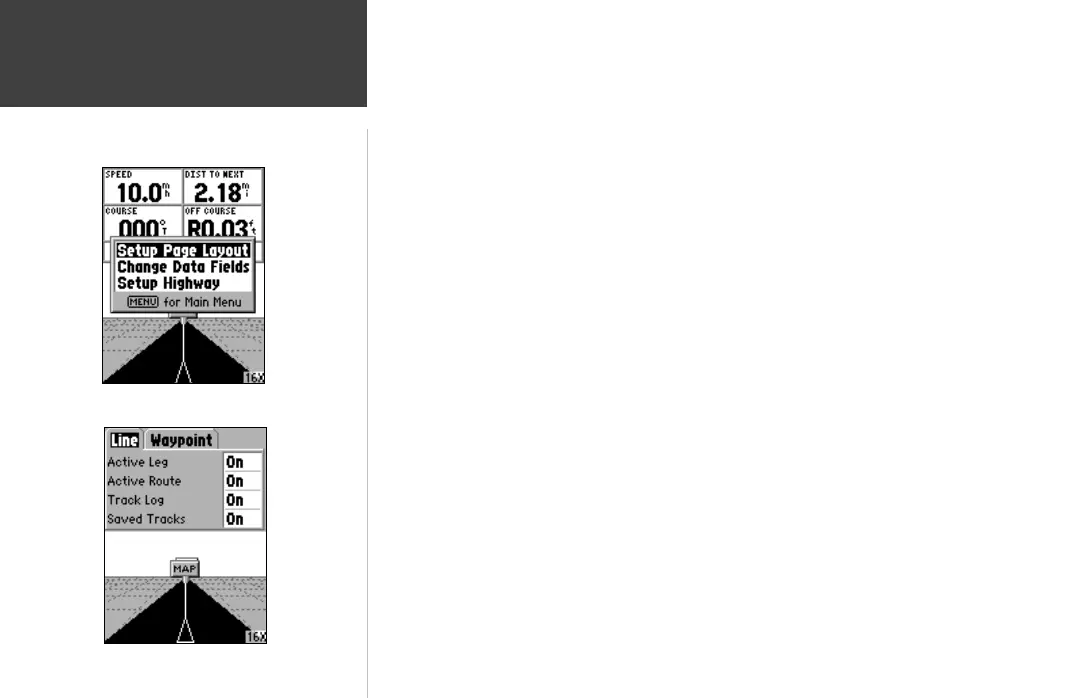
Setup Highway —
This option contains the Highway Setup features. The features are
arranged on a tab menu making it easy to locate the different setup items. To select an
option from a Menu Tab, highlight the desired selection then press ENTER.
Setup Highway — ‘Line’ Tab
The ‘Line’ Tab contains the On/Off settings for Active Leg, Active Route, Track Log and
Saved Tracks. To change a setting, highlight the appropriate fi eld then press ENTER.
Make your new selection, then press ENTER to accept the selection.
Active Leg —
If ‘Off’ is selected, the Active Leg of the Graphic Highway will not be
displayed.
Active Route —
If ‘Off’ is selected, the Graphic Highway will not be displayed.
Track Log —
If ‘Off’ is selected, the Track Log will not be displayed.
Saved Tracks —
If ‘Off’ is selected, Saved Tracks will not be displayed.
Setup Highway — ‘Waypoint’ Tab
The ‘Waypoint’ Tab contains the On/Off settings for Next, Route, and Other. To change
a setting, highlight the appropriate fi eld then press ENTER. Make your new selection,
then press ENTER to accept the selection.
Next —
This setting determines if the next waypoint in a Route will be displayed. If
‘On’ is selected, you will see the next waypoint in the Route. If ‘On’ is selected and the
Route option is set to ‘Off’, only the Next Waypoint in the Route will be displayed.
Route —
This setting determines if the waypoints in a Route will be displayed. If this
selection is set to ‘Off’, Route Waypoints will not be on the Graphic Highway.
Other —
This setting determines if nearby waypoints are displayed.
Setup Highway Page
Highway Page Options
Highway Page
190-00294-00_0B.indd 20 9/25/2002, 2:37:18 PM

 Loading...