Do you have a question about the Garmin GPSMAP 720/720s and is the answer not in the manual?
Provides quick methods for common operations and navigation.
Explains how to interpret instructions and text in the manual.
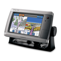
Identifies the physical components of the GPSMAP 700 series.
Guide for configuring initial settings when first turning on the device.
How to adjust screen brightness and color schemes for optimal viewing.
Instructions on using SD cards for data storage and transfer.
How to check software version, map version, and unit ID.
Using the primary map view for planning and navigation.
Explanation of chart symbols and viewing object information.
Steps to set a destination and navigate using the chart.
Changing map orientation, zoom detail, world map, and heading line.
Configuring spot soundings, depth shading, and navaid symbols.
Displaying POIs, photos, marine services, and customizing vehicle icon.
Overview of identifying and tracking other vessels using AIS.
Introduction to Perspective 3D, Mariner's Eye 3D, and Fish Eye 3D views.
Details on enhanced features provided by BlueChart g2 Vision data cards.
Using the Fishing chart for detailed bottom contours and satellite imagery.
Displaying animated tide and current direction indicators.
Creating optimal paths to destinations using Auto Guidance.
Selecting and customizing multi-screen layouts.
Displaying data fields on combination screens.
FAQ covering common navigation tasks and features.
Overview of Go To, Route To, and Guide To navigation.
Storing, editing, and managing waypoint data.
Creating, saving, and navigating custom routes.
Recording, saving, and managing boat track logs.
Connecting and using the autopilot with the chartplotter.
Information on nearby marine services like fuel and repairs.
Searching for and navigating to various types of destinations.
Navigating to previously saved waypoints and routes.
Navigating along a saved track log.
Information on tides, currents, and celestial data.
Viewing engine and fuel status via gauges.
Displaying wind speed and direction data.
FAQ for common device settings and adjustments.
Using simulator mode for practice or indoor use.
Setting sound, language, and navigation preferences.
Setting parameters for Auto Guidance path calculation.
Setting navigation, system, and sonar alarms.
Copying, backing up, and restoring user data.
Steps to activate and start the radar transmission.
Overview of available radar modes (Cruising, Harbor, Offshore, Sentry).
Setting up a safety zone with alarms.
Using Variable Range Marker and Electronic Bearing Line.
Adjusting settings for optimal radar performance.
Superimposing radar data onto chart views.
Overview of sonar display types: full-screen, split-zoom, split-frequency.
Viewing graphical logs of depth and temperature readings.
Setting scroll speed, surface noise, and target display.
Configuring shallow water, deep water, temperature, and fish alarms.
Setting keel offset and water temperature offset.
Features available when connecting chartplotter to VHF radio.
Viewing and managing DSC call logs and contacts.
Displaying trails of tracked vessels on charts.
Setting up and making routine radio calls.
Details on physical, GPS performance, and power specifications.
Procedure to calibrate the touchscreen if unresponsive.
Capturing screens, viewing system info, and event logs.
Resetting all user settings to default.
Compatibility and connection information for NMEA networks.
Information on registering the device and contacting support.
| Display Resolution | 800 x 480 pixels |
|---|---|
| GPS Receiver | High-sensitivity GPS |
| Waterproof Rating | IPX7 |
| Networking | NMEA 2000, NMEA 0183 |
| SD Card Slot | Yes |
| Routes | 100 |
| Antenna | Internal |
| Display Size | 7 inches |
| Display Type | WVGA |
| Charting | Yes |
| Mounting Options | Flush mount |
| Waypoints | 5, 000 |

