Do you have a question about the Garmin GPSMAP 700 and is the answer not in the manual?
Quickly access common functions like returning to the Home screen and adjusting settings.
Explains how to interpret instructions, including the use of arrows for sequential selection.
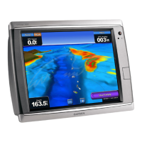
Identifies and describes the function of the chartplotter's front and back panel controls and connectors.
Instructions on how to power on the GPSMAP 700 series chartplotter using the Power key.
Guides users on how to adjust screen brightness manually or automatically for optimal visibility.
Details on how to insert or eject SD cards for data storage and map updates.
How to access device information like software version, unit ID, and map details.
Using the primary chart view for planning courses, viewing map data, and navigation.
Provides a 3D view from above and behind the boat for enhanced visual navigation.
Offers an underwater 3D view of the sea or lake floor using depth contour lines.
Automatically creates and suggests the best path to a destination using chart information.
Steps to navigate using the chartplotter by setting a destination and following a course or route.
Information on marking, saving, editing, and navigating to waypoints.
Instructions for creating, saving, editing, and navigating saved routes.
Details on showing, saving, editing, and retracing the boat's active track log.
How to search for and navigate to nearby marine services like fuel or repair locations.
Methods for searching for destinations by name and initiating navigation.
Information on tides, currents, and celestial data displayed on the chartplotter.
Accessing data related to the boat's systems, including engine and fuel gauges.
Viewing and customizing engine and fuel gauge displays and alarms.
Settings for sound, language, and other display-related preferences.
Customizing route labels and turn transition settings for navigation.
Setting parameters for Auto Guidance, including safe depth and shoreline distance.
Configuring various alarms, including navigation, system, and safety alarms.
Procedures for copying, backing up, and restoring chartplotter data.
Instructions for connecting, powering on, and transmitting radar signals.
Overview of available radar modes like Cruising, Harbor, Offshore, and Sentry.
Tips and procedures for adjusting radar settings for optimal performance and clarity.
Describes the different sonar display views: full-screen, split-zoom, and split-frequency.
Customizing sonar screen appearance, including scroll speed, noise, and depth lines.
Setting up alarms for shallow water, deep water, water temperature, and fish detection.
How the chartplotter alerts users to DSC distress calls received from a VHF radio.
Procedure for initiating an MOB distress call from the chartplotter via VHF radio.
Using the chartplotter to set up and make individual routine calls via VHF radio.
Technical specifications for the GPSMAP 700 series chartplotter.
Steps to calibrate the chartplotter's touchscreen if it becomes unresponsive.
Information on connecting to NMEA 0183 and NMEA 2000 networks and data configuration.
| Display Resolution | 800 x 480 pixels |
|---|---|
| Routes | 100 |
| SD Card Slot | Yes |
| Antenna | Internal |
| Display Size | 7 inches |
| Waterproof | Yes, IPX7 |
| Preloaded Maps | Yes |
| Waypoints | 3000 |
| Track Log | 10, 000 points |
| NMEA Input/Output | NMEA 0183, NMEA 2000 |