Do you have a question about the Garmin GPSMAP 78 and is the answer not in the manual?
Instructions for obtaining GPS lock and overview of device buttons.
Covers creating, navigating, editing, and deleting waypoints.
How to build, modify, navigate, and view routes.
Explains tracks and how to configure recording settings.
Covers current and saved track operations.
Explains compass use and how to calibrate it.
Covers downloading and navigating geocaches.
How to change data fields and lists their options.
Configuration for GPS, language, battery, and serial interface.
Nautical charts, spot soundings, light sectors, and marine alarms.
Guidance methods and route calculation options.
Saving, editing, deleting, and changing device profiles.
GPS accuracy, altimeter/compass, and tips for maximizing battery life.
Solutions for unresponsive screen/buttons and restoring factory defaults.
Troubleshooting steps for no satellite signal.
| Sport (fitness, running) | No |
|---|---|
| Marine (chartplotters, sounders) | Yes |
| Routes quantity | 200 |
| Number of waypoints | 2000 |
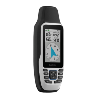
| Form factor | Handheld |
| Interface | NMEA 0183, USB |
| Display diagonal | 2.6 \ |
| Display resolution | 160 x 240 pixels |
| Display number of colors | 65536 colors |
| Display size (HxV) (imperial) | 1.6 x 2.2 \ |
| Battery type | AA |
| Battery life (max) | 20 h |
| Battery technology | Nickel-Metal Hydride (NiMH) |
| Number of batteries supported | 2 |
| Depth | 30 mm |
|---|---|
| Width | 66 mm |
| Height | 152 mm |
| Weight | 218.3 g |