Do you have a question about the Garmin GPSMAP 740 and is the answer not in the manual?
Identifies and describes the physical components and connections of the chartplotter.
Guides through the initial configuration steps upon first use.
Explains how the device acquires satellite signals for location.
Details on using the primary navigation map for course planning and viewing.
Automatically creates the best path to a destination using chart data.
Provides a detailed 3D view from above and behind the boat for navigation.
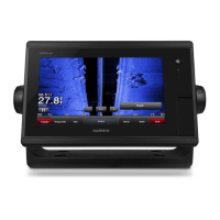
Offers an underwater 3D view of the sea floor, showing suspended targets.
Guide on navigating to nearby fuel, repairs, and other services.
Set parameters for calculating Auto Guidance lines.
Steps to turn on and transmit radar signals.
| Display Size | 7 inches |
|---|---|
| Display Type | WVGA |
| Resolution | 800 x 480 pixels |
| Water Rating | IPX7 |
| Chartplotter | Yes |
| SD Card Slot | Yes |
| Bluetooth | No |
| Wi-Fi | No |
| Map Data | BlueChart g2 |
| GPS Receiver | High-sensitivity |
| Waypoints/Routes | 100 routes |
| NMEA Input/Output | NMEA 0183 |
| Sonar Support | Yes |