Do you have a question about the Garmin RV 890 and is the answer not in the manual?
Provides a detailed explanation of the device's physical components and their functions.
Instructions for securely installing and powering the navigation device within a vehicle.
Steps for attaching the device's screw-down mount to a vehicle's dashboard.
Guide to fitting the ball mount adapter for flexible device positioning.
Procedures for powering the device on, off, or entering power saving mode.
Explanation of how the device obtains satellite data to determine its location.
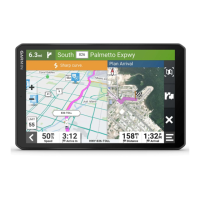
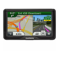
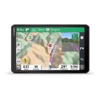
Overview of the main interface, including shortcuts and navigation elements.
How to launch applications from the home screen or app drawer.
Customize the home screen with frequently used app shortcuts.
Access and manage notifications received on the device.
Explanation of icons indicating device features and status in the status bar.
Basic gestures and interactions for operating the device via its touchscreen.
Manually adjust the display brightness for optimal visibility.
Create a new profile for a specific vehicle, like an RV or camper.
Details on the default profile for standard automobiles and its limitations.
Change between different vehicle profiles for accurate routing.
Configure propane tank details for route planning with restrictions.
Modify vehicle profile information, including dimensions and speed.
Turn on or off various audible and visual driver alerts.
Device warnings for speed and red light cameras.
Explanation of how routes are calculated and used for navigation.
Initiate navigation to a chosen destination.
Begin navigation by selecting a point directly on the map.
Navigate quickly to a pre-set home location.
Update the device's stored home address.
Visual lane assistance for upcoming turns and exits.
View upcoming navigation instructions and route details.
Display the complete planned route on the device's map.
Information and prompts provided as the device guides you to your destination.
Locate parking spots close to your final destination.
Modify an ongoing route, such as adding stops or shaping.
Insert additional destinations into an active navigation route.
Manually adjust the route's path to favor specific roads or areas.
Temporarily alter the route to bypass specific roads or distances.
Select route calculation preferences like fastest time or shortest distance.
End the current navigation session.
Use predictive routing based on travel history and patterns.
Settings to avoid traffic, tolls, and specific geographic zones.
Manage route preferences to bypass areas with traffic congestion.
Exclude toll roads, bridges, or congestion areas from routes.
Avoid roads requiring specific toll payment methods or stickers.
Exclude specific road characteristics from navigation routes.
Avoid areas with environmental or emissions restrictions.
Define personal preferences to avoid specific roads or areas.
Mark a specific road segment to be excluded from routing.
Define geographic areas to be excluded from route calculations.
Temporarily deactivate a custom avoidance rule.
Remove custom avoidance rules from the device.
Use keywords to search for addresses, businesses, or points of interest.
Locate and navigate to a specific street address.
Browse and select locations by category like restaurants or fuel stations.
Refine searches within categories using quick search lists.
Display and interpret search results on the map and in a list.
Modify the geographic area used for location searches.
Create and use custom points of interest with alerts.
Install software to manage custom points of interest.
Find and use custom points of interest loaded onto the device.
Find parking spots, filtering by availability and price.
Locate parking options in proximity to the current device position.
Interpret visual cues for parking availability, type, and price.
Search for specific types of locations using on-screen prompts.
Search for and navigate to a specific road intersection.
Find a location by entering latitude and longitude coordinates.
Use Foursquare for location search and check-ins.
Link the device with a personal Foursquare account via the Garmin Drive app.
Search Foursquare locations, including online database integration.
Access detailed information for Foursquare locations like ratings and hours.
Use TripAdvisor data for points of interest and ratings.
Search for and discover TripAdvisor-listed locations.
Access a history of the last 50 locations searched or selected.
Remove the history of recently found locations.
Access details about current position, useful for emergency services.
Locate nearby hospitals, police stations, fuel stations, or roadside assistance.
Generate directions to the device's current geographical position.
Create shortcuts in the Where To? menu for quick access.
Delete shortcuts from the Where To? menu.
Save favorite locations for future access.
Save a searched or selected location with a custom name.
Save the device's present geographical coordinates.
Modify details, categories, or map symbols for saved locations.
Organize saved locations by assigning custom categories.
Remove saved locations from the device's memory.
Access interactive tools on the map screen for quick feature access.
End the current navigation route.
Modify an active route, including detours or skipping waypoints.
Adjust audio and notification volumes directly from the map screen.
Display upcoming cities and services along highways or routes.
Show points of interest and upcoming locations along the current road or route.
Personalize the types of locations displayed in the Up Ahead tool.
Details on upcoming cities and services at highway exits.
Symbols indicating potential road hazards and conditions.
Icons for vehicle restrictions like height, weight, and width.
Alerts for road conditions like sharp curves, steep hills, or risk of grounding.
Access trip statistics like distance and speed from the map screen.
Personalize the data displayed for trip statistics.
Review a recorded history of paths traveled by the device.
Clear trip data, odometers, and maximum speed.
Display real-time traffic incidents and delays along the route.
Visualize traffic flow and congestion levels on the map interface.
Locate and view details of specific traffic incidents.
Personalize map display, including layers and data fields.
Select map elements like points of interest to display.
Modify the information shown in the map's data fields.
Adjust map view between 2-D (North Up, Track Up) and 3-D.
Connect the device with a smartphone via Bluetooth.
Considerations for maintaining a stable device connection.
Connect other Bluetooth devices like headsets.
Use the smartphone app to send navigation destinations to the device.
Receive phone notifications like texts and calls on the navigation device.
Display and handle incoming notifications from a paired smartphone.
Use the device for making and receiving phone calls wirelessly.
Initiate phone calls using the device's interface or voice commands.
Answer or dismiss incoming phone calls.
Features during an active call, like conference calls or audio transfer.
Set up speed dial contacts for quick access.
Use Bluetooth headsets for audio navigation prompts.
Manage Bluetooth connectivity for calls and app features.
Customize which app notifications appear on the device for Android.
Filter notifications from Apple devices by category.
Temporarily unpair a Bluetooth device.
Permanently remove a Bluetooth device from the paired list.
Obtain traffic information through a connected smartphone.
Get traffic data via a dedicated traffic receiver accessory.
Display real-time traffic conditions and flow on the map.
Locate and view details of specific traffic incidents.
Guidelines for effective voice interaction with the device.
Initiate navigation and other functions using voice commands.
Use voice commands to inquire about estimated arrival time.
Make phone calls hands-free using voice commands.
Adjust device settings like volume via voice commands.
Access and utilize applications on the device.
Access the complete user manual directly from the device.
Create and save multi-destination trips for future navigation.
Modify saved trips by changing stop order or adding/removing destinations.
Rearrange trip stops for a more efficient route.
Find and add points of interest to a planned trip.
Customize route calculation preferences for saved trips.
Start navigation for a previously planned and saved trip.
Modify and save the current navigation route as a trip.
Retrace your path back to a previous location using recorded track data.
Navigate along a recorded track segment using TracBack.
Convert a recorded track into a navigable trip.
Wirelessly connect the device to a Fusion stereo via Bluetooth.
Connect the device to a Fusion stereo over a Wi-Fi network.
Control music playback from a connected stereo.
Choose the audio source (e.g., radio, AUX) for playback control.
Use on-screen buttons to manage media playback.
Adjust volume, tones, and other audio settings for different zones.
Control audio volume for specific speaker zones.
Mute audio from all connected stereos or a specific one.
Modify bass, treble, and other tone settings for audio output.
Turn off loudness compensation for specific speaker zones.
Set input gain for connected auxiliary audio devices.
Group speakers into zones for individual audio level control.
Configure volume limits, subwoofer levels, and balance for speaker zones.
Control subwoofer cutoff frequency to optimize sound blending.
Configure digital signal processing settings for audio optimization.
Adjust DSP parameters for speakers and amplifiers in audio zones.
Save and manage AM/FM radio stations for easy access.
Tune to a station and save it as a preset.
Choose a saved radio station from the preset list.
Delete saved radio station presets.
Configure speaker zones, tuner regions, device names, and search features.
Detailed settings for managing individual speaker zones.
Assign a custom name to a speaker zone.
Options for route calculation, avoidances, tolls, and travel history.
Configure map display, vehicle icons, voice language, and map detail.
Activate installed map products on the device.
Connect the device to a Wi-Fi network for updates and services.
Activate the device's Bluetooth capabilities for wireless connections.
Adjust alerts for driver awareness features like speed cameras.
Enable and configure the traffic feature for real-time traffic data.
Adjust screen brightness, theme, wallpaper, sleep mode, and font size.
Configure volumes, notification sounds, and do-not-disturb preferences.
Set volume levels for various audio outputs and notifications.
Configure an alarm with a specific time.
Manage GPS and location tracking features for navigation and battery saving.
Select the language for the device's software interface.
Configure the device's date, time zone, and 12/24-hour format.
Access information about system status, legal details, and regulatory compliance.
Reset device settings to their original factory defaults.
Access regulatory and compliance details electronically stored on the device.
Technical details of the device, including operating temperature and frequencies.
Methods and considerations for charging the device's internal battery.
Access customer support and resources.
Update device maps and software wirelessly via Wi-Fi.
Update maps and software using the Garmin Express computer application.
Download and install the Garmin Express software on a computer.
Guidelines for maintaining the device's physical condition and avoiding damage.
Proper methods for cleaning the device's external housing.
Instructions for safely cleaning the device's touch-sensitive display.
Tips to prevent device theft when not in use.
Reset the device to its factory settings if it becomes unresponsive.
Detach the device, mount, and suction cup from the vehicle.
Detach the device mount from the suction cup assembly.
Safely remove the suction cup from the windshield.
Solutions for suction cup adhesion issues.
Troubleshoot loose device mount during driving.
Resolve problems with the device failing to detect GPS signals.
Diagnose and fix device charging issues in the vehicle.
Improve battery life and address rapid battery drain.
Troubleshoot Bluetooth connectivity issues with a smartphone.
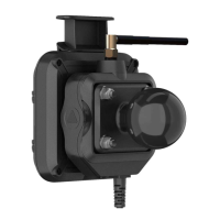
Information and setup for the Garmin PowerSwitch accessory.
Key factors for mounting the Garmin PowerSwitch device.
Install the Garmin PowerSwitch device.
Open the device's front cover for electrical connections.
Wire and connect accessories to the Garmin PowerSwitch.
Connect vehicle signals to control PowerSwitch outputs.
Connect the Garmin PowerSwitch to the vehicle's power supply.
Connect the Garmin PowerSwitch to a compatible Garmin navigation device.
Technical specifications for the Garmin PowerSwitch device.
Common issues and solutions for the Garmin PowerSwitch.
Resolve persistent disconnection problems with the PowerSwitch.
Troubleshoot why accessories are not receiving power from the PowerSwitch.
Connect and view backup camera feeds on the device.
Wirelessly pair a BC 35 backup camera with the navigation device.
Connect a wired backup camera using a video mount accessory.
Display video feeds from connected backup cameras.
Switch between multiple backup cameras if connected.
Adjust video display orientation (mirror/flip) for backup cameras.
Connect a dash camera to the device's powered mount.
Information on device storage and memory card usage.
Details on purchasing and using memory cards for storage expansion.
Insert and format a memory card for additional storage.
Format a memory card using the device's utility.
Establish a USB connection between the device and a computer.
Move files from a computer to the device's storage.
Copy GPX route or waypoint files from a computer to the device.
Share navigation data (waypoints, routes) via the mobile app.
Load GPX data from external sources into the device via the mobile app.
Save navigation data in GPX format onto a microSD card.
Load GPX data from a microSD card onto the device.
Acquire and install new map products for the device.
Guidance on buying compatible accessories for the device.
| Display Resolution | 1280 x 800 pixels |
|---|---|
| Preloaded Maps | North America |
| Voice Control | Yes |
| Bluetooth | Yes |
| Wi-Fi | Yes |
| Battery Type | Rechargeable lithium-ion |
| Bluetooth Calling | Yes |
| Live Traffic Updates | Yes, via Garmin Drive app |
| Weather Updates | Yes, via Garmin Drive app |
| Display Size | 8 inches |
| Compatibility | Garmin Drive app |
| Display Type | Multi-touch, glass |