Do you have a question about the Honda 2010 Fit and is the answer not in the manual?
| Touchscreen | Yes |
|---|---|
| Voice Recognition | Yes |
| Display Type | LCD |
| Voice Guidance | Yes |
| USB Port | Yes |
| Auxiliary Input | Yes |
| GPS Antenna | Internal |
| Real-Time Traffic | XM NavTraffic (subscription required) |
| Map Updates | Available |
Overview of the manual's structure and content.
Explanation of the navigation system's function and components.
Warnings regarding accessories and GPS reception.
Safety advice for using the navigation system while driving.
Explanation of map features like current street and street types.
Terms and conditions for using the navigation system DVD.
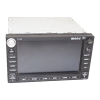
Identification and function of physical buttons and controls on the unit.
Using the joystick for display navigation and selection confirmation.
INFO, MAP/GUIDE, MENU, SETUP, CANCEL, ZOOM, AUDIO button functions.
How to interact with the display using touch input.
Introduction to the voice control system, its components, and general use.
Step-by-step guide for giving voice commands to the system.
Tips to enhance the accuracy and performance of voice recognition.
Methods for selecting items via voice, joystick, or touch.
Inputting text and characters using the on-screen keyboard.
The process the system undergoes when the ignition is turned on.
Acknowledging the disclaimer and viewing the clock screen.
Explanation of icons, symbols, and color coding on the map.
How to zoom and scroll through map views.
Viewing vehicle's current position, address, and GPS data.
Visual representation of system features and their interactions.
Overview of options: Address, Places, Map Input, Previous Dest., Today's Dest., Address Book, Go Home.
Steps to select state/province and city for address input.
Inputting the street name for an address or intersection.
Inputting the street number for a destination.
Entering a destination by specifying intersecting streets.
Finding destinations by category, name, or phone number.
Navigating categories and subcategories to find a POI.
Finding POIs using a keyword search.
Sorting POIs by distance, city vicinity, or exact name.
Locating a destination using its stored phone number.
Selecting a destination visually on the map.
Displaying maps of selected cities or states for destination input.
Displaying a map of the continental USA for destination selection.
Selecting a destination from a list of past routes.
Creating and managing multi-destination trips.
Selecting a stored address from the personal address book.
Methods for entering addresses into the address book.
Navigating to the stored home address.
The initial screen for calculating a route and adding destinations.
Selecting route preferences like Direct, Easy, or Minimize Freeways.
Scrolling through and viewing different calculated routes.
The main map display showing the route line for verified and unverified roads.
How the system provides turn-by-turn voice and visual prompts.
Detailed explanation of icons, symbols, and color coding on the map.
An alternative view for route info with icons and progress indicators.
Visual indicator of trip progress towards the destination.
Display of remaining distance and estimated time to reach the destination.
A list of upcoming maneuvers and directions for the route.
Searching for and displaying freeway exit information.
Selecting between single-screen and split-screen map display modes.
How to change and understand different map scale levels.
Setting map display to North-up or Heading-up.
Explanation of how the destination icon represents location.
Displaying icons for points of interest on the map.
Displaying icons for one-way streets on specific map scales.
Manually selecting or hiding icons on the map display.
Fine-tuning the display of specific icons on the map.
System behavior and recalculation when deviating from the route.
Tracking paths off mapped roads using "breadcrumbs".
Obtaining and storing the vehicle's current position data.
System messages and warnings for route situations like unverified areas.
Options to alter the current route, add waypoints, or change destination.
Adding interim stops (pit stops) along the route.
Procedures for adding waypoints along or around the route.
Deleting, avoiding streets, or detouring/changing routing methods.
Cancelling routes, returning to map, and changing destinations via voice or joystick.
Resuming a trip after the vehicle has been restarted.
Accessing Voice Command Help, Map Legend, Calendar, Calculator.
Getting help and lists of available voice commands.
Understanding map symbols and setting up calendar reminders.
Setting up daily schedule entries with titles, messages, and icons.
Using the built-in calculator and converting measurement units.
Overview of setup screens and adjustment of brightness/volume.
Adjusting screen brightness and navigation voice volume.
Selecting Day, Night, or Auto display modes and their effects.
Customizing clock display, prompt frequency, and contrast.
Accessing personal info, address book, PIN, and user names.
Accessing and adding addresses to the personal address book.
Modifying address details, selecting POIs, and editing phone numbers.
Specifying categories and editing/deleting address entries.
Setting home address and PIN for personal information protection.
Managing PINs and deleting past destinations.
Configuring rerouting behavior (Automatic/Manual) and guidance options.
Differences in guidance for verified vs. unverified roads.
Examples of routing with unverified areas enabled or disabled.
Selecting areas on the map to be excluded from routing calculations.
Defining search distance for waypoints along the route.
Selecting display mode and configuring vehicle settings like off-road tracking.
Manually adjusting the vehicle's position on the map display.
Viewing system details and configuring keyboard, units, and voice feedback.
Adjusting clock, DST, and time zones, including auto settings.
Configuring auto time zone and DST schedules.
Adjusting map and menu colors for optimal display contrast.
Steps required after power loss, including security code entry.
Inputting the 4-digit anti-theft code to activate the system.
Acquiring satellite signals and aligning GPS coordinates with map roads.
Overview of inherent limitations in navigation system performance.
Factors affecting GPS signal reception and potential solutions.
Explains potential issues with missing or outdated POI data.
Procedures for reporting errors and contacting Honda Customer Service.
When to consult a dealer and how to obtain navigation software updates.
Step-by-step guide for replacing the navigation system DVD.
Using PC cards and CDs for audio playback and system control.
Using voice commands to control CD audio playback.
Overview of the system's map coverage for US states and Canada.
List of US states and cities with detailed map coverage.
Navigation system differences in Alaska and Hawaii.
Setup and shipping differences for vehicles in Hawaii.
Addresses common issues with map display, voice commands, and address input.
Addresses issues with display, PC cards, and accessories.
Addresses common questions about routing, map orientation, and guidance.
Addresses questions on purchasing DVDs, coverage, errors, and limitations.
Addresses display problems and using PC cards.
Troubleshooting PC card and music file playback issues.
Troubleshooting CD-R playback and voice command issues.
Addresses clock behavior, time zones, and daylight saving time.
Finding security codes and language availability queries.
Solutions for common screen error messages and system issues.
Solutions for errors like no alternate route or destination not found.
Definitions of terms used in the navigation system manual.
Overview of Global, Navigation General, and Information screen commands.
Commands for controlling map display, scale, and icon visibility.
Voice commands to find various types of places and businesses.
Voice commands for controlling the radio and audio functions.
Voice commands for controlling CD and PC card audio playback.
Voice commands specific to Information and Setup screens.
Commands for on-screen elements and keyboard input assistance.
Grants the user a license to use the software on the device.
Conditions for transferring software rights and export compliance.