Safety
precaution
To ensure proper and safe use of the equipment, please carefully
read and follow the instructions in the Operation Manual.
Tamagawa Office:
2-13-24 Tamagawa, Ota-ku, Tokyo, 146-0095 Japan
Tel: +81-3-3756-6501 Fax: +81-3-3756-6509
Uenohara Office:
5278 Uenohara, Uenohara-shi, Yamanashi, 409-0112 Japan
Tel: +81-554-20-5860 Fax: +81-554-20-5875
• Design and specifications are subject to change without notice.
For details, please contact:
www.koden-electronics.co.jp
overseas@koden-electronics.co.jp
08.08 Printed in Japan
Type name GTD-110/150
Display GTD-110 10.4 inch High Brightness TFT Color LCD
GTD-150 15 inch High Brightness TFT Color LCD
Map mode Mercator projection
Display mode North-up, East-up, South-up, West-up, Course-up
(Waypoint), Head-up, Centered North-up
Track zooming range 0.01 to 3600 nm (or 0.02 to 6600 km)
Display
Effective map creation area
Below latitude 75 degree
Plotting interval Time 1, 2, 5, 10, 20, 30, 60, 120, 300, 600 sec
Distance
0.01, 0.02, 0.05, 0.1, 0.2, 0.5, 1.0, 2.0, 5.0, 10.0 nm (km)
No. of plots 2000, 4000, 7000 (maximum plot) x 7 blocks
Track color 7 colors
Position data display Lat/lon, Loran-C LOP
Navigation data display Own ship's position, Own ship's course, Own ship's speed,
Waypoint position, Waypoint bearing, Waypoint distance,
POB position, POB bearing, POB distance, Cursor posi-
tion, Cursor bearing, Cursor distance
Position registration 8300
Mark color 7 colors
Mark shape
(The marks are only useable in Mark Editing mode)
Mapping Mapping nodes 500 points x 7 blocks
Display color 7 colors
Other ships plot 10 ID x 1000 points
Route memory 50 routes x 50 waypoints
Chart C-Map NT / NT+ / NT MAX
Data card C-Map User C-Card
Alarm Arrival, POB, Cross track error, Depth, Grounding
Positional correction By cursor or by lat/long data
Magnetic compass correction Manual, Auto
Input data format NMEA 0183 Ver 2.0/1.5 (GGA, GLL, VTG, ZDA, RMC,
MSS, MTW, TTM)
Output data format
NMEA 0183 Ver 2.0 (APB, GGA, GLL, VTG, XTE, ZDA, GTD)
Memory backup
By Lithium battery (for SRAM backup) and Non-volatile ROM
Other functions Loran-C LOP, Ring markers
Power supply voltage 10.8 to 31.2 VDC
Power consumption: GTD-110 Less than 20 W (at 24 VDC)
GTD-150 Less than 40 W (at 24 VDC)
Operating temperature -15
°
C to +55
°
C (+5
°
F to +131
°
F)
Waterproof Resistive against driven water, in compliance with IPX5
Display
GTD-110/GTD-150
With hard cover 1
DC power cable CW-253-2M
5P connector fitted one end
1
Fuse F-7161 10 A 1
Operation manual 93151542 1
SPECIFICATIONS EQUIPMENT LIST
CONNECTIONS
DIMENSIONS AND WEIGHT
GPS sensor GPS-20A For GPS signal reception 0.6 kg
DGPS sensor KBG-2 For GPS signal reception 1.8 kg
Junction box JB-10 1-IN/3-OUT 0.42 kg
Power rectifier PS-003A With two 5 A fuses 2.8 kg
AC power cable VV-2D8-3M Flying leads on each end 3 m
Standard equipment
Options
Display unit
Unit: mm (inch)
Weight: 10 kg (22 lbs)
Weight: 6.5 kg (14.5 lbs)
380
(14 15/16)
320
(12 5/8)
340
(13 3/8)
320
(12 5/8)
29.5
(1 3/16)
100
(3 15/16)
24
(15/16)
138
(5 7/16)
224.5 (8 7/8)
390
(15 3/8)
430
(16 15/16)
173
(6 13/16)
24
(15/16)
67
(2 5/8)
150
(5 7/8)
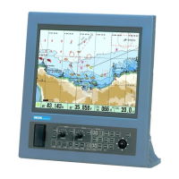
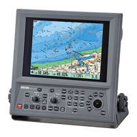
GTD-150
GTD-110
10.4-inch/15-inch Color LCD
Chart Plotter
GTD-110/150
DGPS sensor
KBG-2
GPS sensor
GPS-20A
10.8 to 31.2 VDC
100/115 VAC
200/230 VAC
VV-2D8-3M
CW-253-2M
Power rectifier
PS-003A
Junction box
JB-10
Display unit
Color fish finder
Marine radar
Marine radar
(with ATA built-in)
IN/OUT
IN/OUT
OUT
OUT
Solid lines: Standard devices and connections.
Dashed lines: Optional devices and connections.
GTD-110
GTD-150
Wherever you go, you can rely on it!