Do you have a question about the Leica Geosystems GS16 and is the answer not in the manual?
Provides an introduction to safety directions and explains warning message types (DANGER, WARNING, CAUTION, NOTICE).
Details various hazards associated with product use, including electrocution, dropping, and lightning.
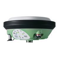
Identifies and describes the physical components and connectors of the GS14/GS16 instrument.
Describes the ON/OFF and Function buttons on the GS14/GS16 keyboard and their functions.
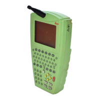
Explains how the GS14/GS16 instrument is operated via its buttons or a field controller.
Details the setup procedure for using the instrument as a post-processing base station.
Describes the setup procedure for real-time base stations with optimal radio coverage.
Details the setup procedure for using the instrument as a real-time rover.
Explains principles for first-time use, charging, and discharging of batteries.
Provides step-by-step instructions for safely changing the GS14/GS16 instrument battery.
Instructions for inserting, removing, and handling microSD cards for data storage.
Explains the meaning of the status indicator LEDs on the GS14/GS16 instrument.
Provides guidelines for achieving correct GNSS survey results, focusing on signal reception and setup.
Explains factors affecting accuracy and provides precision values for differential measurements.
| Type | GNSS Receiver |
|---|---|
| RTK Accuracy (Horizontal) | 8 mm + 1 ppm |
| RTK Accuracy (Vertical) | 15 mm + 1 ppm |
| Internal Memory | 8 GB |
| Operating Temperature | -40°C to +65°C |
| Ingress Protection | IP67 |
| Frequency Bands | L1, L2, L5 |
| Signal Tracking | GPS, GLONASS, Galileo, BeiDou |
| Static Accuracy (Vertical) | 5 mm |
| Communication | Bluetooth, Wi-Fi |
| Power Consumption | 4.5 W |