General Information
LEICA SR20 User Manual-1.1.0en
6
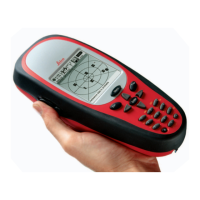
The Leica SR20
The Leica SR20 GPS receiver was designed to provide the
Land Surveying community with a reliable, rugged and
accurate GPS receiver that is also flexible enough to fit
both sub-meter and centimeter accurate land surveying
requirements. The Leica SR20 represents a true turnkey
GPS solution by integrating the GPS receiver and antenna
within the chassis of a handheld data collector. You will find
the SR20 is extremely easy to use and yet has the all the
power you would expect out of a Leica GPS receiver.
Overview of the User Manual
The User Manual is intended to provide information
concerning setup, safety, storage and technical data of the
SR20 and accessories. For additional information on the
use and operation of the SR20, please refer the SR20
"Getting Started Guide" (provided separately). For informa-
tion concerning the use and interaction between Leica Geo
Office and the SR20, please refer to the Leica Geo Office
online help system.
 Loading...