Do you have a question about the Lowrance LMS-480 and is the answer not in the manual?
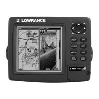
Details general and sonar/GPS capabilities and specifications of the LMS-480 series units.
Explains the basic principles of sonar operation, including sound waves and echoes.
Explains how the GPS receiver locates position using satellite signals.
Provides background information on GPS technology and the WAAS system.
Explains the text formatting, symbols, and conventions used in the manual.
Outlines the recommended sequence for installing the sonar/GPS unit and accessories.
Guides on installing the Skimmer transducer on transoms, trolling motors, or hulls.
Details criteria for choosing the optimal transducer mounting spot for performance.
Details how to connect the unit's power supply cable to the battery.
Covers bracket, in-dash, and portable mounting options for the sonar/GPS unit.
Instructions for installing memory cards for storing sonar logs and GPS data.
Describes the functions of each key on the unit's keypad.
Instructions for turning the unit on, off, and adjusting backlight.
Describes the main menu and its available function and setup options.
Displays the sonar chart showing underwater conditions and targets.
Controls the unit's ability to pick up echoes for better target detail.
Noise rejection system to improve display quality by evaluating signals.
Describes the three types of sonar alarms: Fish, Zone, and Depth.
How to set shallow and deep water depth alarms for alerts.
Identifies potential fish targets and displays them as symbols.
Allows changing the transducer frequency between 200 kHz and 50 kHz.
Distinguishes between strong and weak echoes for target interpretation.
Saves sonar data to an MMC card for later playback and analysis.
Displays digital data like depth, speed, and temperature on screen.
Resets all unit features, options, and settings to factory defaults.
Steps to troubleshoot power issues when the unit does not power on.
Addresses issues like electrical noise, cable connections, and frozen operation.
Troubleshoots transducer performance, signal issues, and erratic readings.
Discusses electrical noise interference, its causes, and elimination methods.
Describes the functions of each key on the unit's keypad.
Instructions for turning the unit on, off, and adjusting backlight.
Describes the main menu and its available function and setup options.
Displays status of satellite lock-on and position acquisition.
Shows compass rose, travel direction, and waypoint bearing.
Displays course and track from a bird's-eye view on a moving map.
Explains how to zoom and pan the map using the cursor and arrow keys.
How to search for specific locations, addresses, or points of interest.
Quick method to save the current position as a waypoint.
How to select and navigate to a saved waypoint.
Navigating back to the recorded Man Overboard position.
Navigates along a trail from its start point to its end point.
Navigates along a trail in reverse, from its end point to its start.
Measures distance from current position to a selected map point.
Measures distance between two selected points on the map.
How to create an icon at a cursor position on the map.
How to delete icons from the map.
How to create and save a route in the unit or on a computer.
How to follow a route backward, from end to start.
How to erase or delete a specific trail.
Manages trail visibility and other settings like active status.
How to erase waypoints from the list or map.
How to edit a waypoint's name, symbol, or position.
Creates a waypoint by averaging multiple position readings for accuracy.
Sets a waypoint based on distance and bearing from a reference point.
Sets GPS alarms like arrival, off course, and anchor alarms.
How the GPS receiver locks onto satellites for position acquisition.
Configures the NMEA 0183 communication port for data exchange.
Selects the coordinate system for displaying position coordinates.
Configures map fix to find position on printed charts or topographical maps.
Customizes information viewable on Position, Navigation, and Map pages.
Allows practicing navigation features in a simulated environment.
Selects the level of detail for the Earth Map display.
Selects the geodetic datum used for map and chart displays.
Selects which mapping features (waypoints, cities, etc.) are shown.
Sets map orientation (North Up, Track Up, Course Up).
Provides on-screen descriptions for menu items.
Resets all unit features, options, and settings to factory defaults.
Adjusts the display's contrast and brightness levels.
Selects the menu language for the unit's interface.
Sets the unit's local time and date for accurate navigation.
Displays the current software version running on the unit.
Adjusts key press sounds, alarm sounds, and alarm volume.
Prevents trail wandering at slow speeds or when the unit is stopped.
Removes all saved trails from the unit's memory.
Makes trails flash on the screen for better visibility.
Controls how trail updates occur, including automatic creation.
Sets the rate at which trails are updated by time or distance.
Sets units for speed, distance, depth, temperature, and heading.
How to search for specific street addresses.
Finds information about any item selected by the map cursor.
How to search for interstate highway exits and nearby services.
How to search for map places and Points of Interest.
How to search for streets by name.
How to search for intersections between two specified streets.
Lists the geodetic datums supported by the unit for coordinate systems.
Compliance information regarding Federal Communications Commission rules.
| Display Size | 5 inches |
|---|---|
| Resolution | 480 x 480 pixels |
| GPS Receiver | Yes |
| Sonar Frequency | 200 kHz |
| Waterproof Rating | IPX7 |
| Chartplotting | Yes |
| Display Type | LCD |
| Depth Capability | 1000 ft |