Do you have a question about the Magellan Triton Triton 300 and is the answer not in the manual?
Warns against using the device while driving to prevent accidents and ensure focus on the road.
Addresses FCC limits for RF exposure and provides user compliance instructions.
Addresses IC limits for RF exposure and user compliance instructions.
Step-by-step guide to power on the Magellan Triton device by pressing the power button.
Instructions for shutting down or putting the Triton into suspend mode via the power button.
How to adjust units, north reference, coordinate system, and map datum.
How to adjust audio volume and screen brightness levels using slider bars.
Instructions for clearing waypoints and routes from memory, noting data loss.
How to reset the device to its original factory default settings.
How to run tests on audio, video, keypad, and touch screen functions for troubleshooting.
Steps to select and activate a pre-configured profile (Hiking, Marine, Geocaching).
How to modify settings within a profile to suit specific user needs and activities.
Guides on creating waypoints from current location, map points, or by entering coordinates.
Steps to save the current position as a waypoint directly from the map screen.
Alternative method to create a waypoint from current location via the Triton menu.
How to create a waypoint by moving the pan cursor to a desired map location.
Steps to create a waypoint from a specific map location via the Triton menu.
How to manually enter coordinates and details for a custom waypoint from the map screen.
Alternative method to create a custom waypoint by entering coordinates via the menu.
How to find, search, and view saved waypoints from the list.
How to modify existing waypoint information, including proximity alarms.
How to remove a saved waypoint from the device's memory.
An alternative procedure for deleting saved waypoints.
How to add geocache locations to the device from current location, map, or coordinates.
How to create a route by selecting a map point with the cursor without needing coordinates.
Steps to create a route to a previously saved user-created waypoint.
How to create a route to a preloaded location (place waypoint) from the base or detail map.
Steps to create a route to a geocache location from the list of saved geocaches.
How to create a route with multiple destinations strung together.
How to save recorded track data (breadcrumbs) as a trail for later use.
An alternative procedure for saving recorded tracks as trails.
How to create and activate a route back to the starting point using recorded track data.
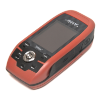
| Type | Handheld |
|---|---|
| Display Size | 2.2 inches |
| Display Type | Color TFT |
| Resolution | 220 x 176 pixels |
| Battery Life | 10 hours |
| Water Resistance | IPX7 |
| Connectivity | USB |
| Waypoints | 500 |
| Routes | 20 |
| Receiver | SiRFstarIII |
| Channels | 12 |
| Track Log | Yes |
| Weight | 5.3 ounces |