Do you have a question about the Magellan Triton 300 and is the answer not in the manual?
Covers essential safety rules for device usage, including driving and general judgment.
Details FCC and IC statements regarding interference and compliance for the device.
Covers powering the device, adjusting display brightness, setting time zone, and changing languages.
Provides tips and methods to conserve battery life for optimal device usage.
Instructions on how to select, turn on, or turn off various navigation screens.
Provides an overview of the Map screen layout and explains the map legend symbols.
Guides on customizing data fields, saving waypoints, and using pan for waypoint creation.
Covers creating routes from the map, backtrack, and customizing map display options.
Instructions for activating, editing, and managing user profiles for different activities.
Guides on customizing navigation, adjusting volume/brightness, and checking memory usage.
Covers clearing memory, restoring factory settings, and configuring device connectivity.
Details methods for creating Go To routes using the pan cursor and saved waypoints.
| Sport (fitness, running) | No |
|---|---|
| Marine (chartplotters, sounders) | Yes |
| Routes quantity | 20 |
| Number of waypoints | 500 |
| Antenna type | Built-in |
| Internal memory | 10 MB |
| Channels quantity | 20 channels |
| GPS accuracy - position | 7 m |
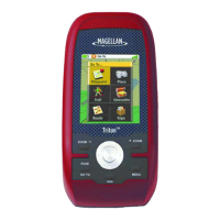
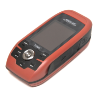
| Form factor | Handheld |
| Display diagonal | 2.2 \ |
| Display resolution | 240 x 320 pixels |
| Compatible memory cards | SD |
| Processor frequency | 266 MHz |
| Battery type | AA |
| Battery life (max) | 10 h |
| Operating temperature (T-T) | -10 - 60 °C |
| Depth | 118.1 mm |
|---|---|
| Width | 54.9 mm |
| Height | 31 mm |
| Weight | 187.1 g |