Do you have a question about the Magellan Trailblazer and is the answer not in the manual?
Emphasizes not relying solely on the device for navigation.
Explains GPS operation by the US Government and accuracy adjustments.
Warns about accuracy affected by satellite geometry.
Advises using only Magellan accessories to avoid damage/voiding warranty.
Defines navigation and historical methods.
Explains coordinate systems and Earth grid lines.
Explains position fixes and how they become waypoints.
Describes using waypoints to navigate back to a starting point.
Explains setting a direct course to a waypoint and reading navigation data.
Details planning a course using waypoints and managing cross-track error.
Describes entering waypoints and understanding UTM coordinates.
Details battery types and external power connection.
Describes optimal placement and use of the GPS antenna.
Explains the steps for initial receiver setup and configuration.
Explains changing between Lat/Lon and UTM display.
Details setting the magnetic or true north reference.
Describes options for displaying local or UTC time.
Explains setting 2D, 3D, or Auto elevation modes.
Covers changing measurement units for distance and speed.
Explains selecting feet or meters for elevation display.
How to adjust the display backlight intensity.
How to adjust the display contrast.
Security feature to prevent accidental activation.
Feature to automatically record position fixes periodically.
Resets receiver settings and erases stored data.
How to delete all saved waypoints and routes.
Explains NMEA standard for data output.
Minimizes speed fluctuations caused by SA.
How to interpret maps and charts with GPS coordinates.
Step-by-step guide to entering, renaming, and deleting waypoints.
How to create, manage, and reverse routes using waypoints.
Explains pointer display and setting a direct course to a waypoint.
Describes the Backtrack feature and the MOB function.
How to enter waypoints using UTM coordinates.
Explains the GPS system and its purpose.
Describes GPS satellite signal reception and ranging principles.
Discusses GPS accuracy, SA, and where to find more information.
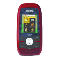
Lists physical and operating specifications of the receiver.
Lists included items and available accessories.
Solutions for a frozen screen, unresponsive keypad, or no power.
Addresses static or frozen position data and potential causes.
Explains normal variations in position data due to variables and SA.
| Display Size | 2.2 inches |
|---|---|
| Battery Life | Up to 18 hours |
| Waterproof Rating | IPX7 |
| Display Type | Color TFT |
| Battery Type | 2 AA batteries |
| GPS Accuracy | 3-5 meters |
| Waypoints | 500 |
| Routes | 20 |
| Map Coverage | Worldwide |
| Track Log | Yes |
| Weight | 5.3 oz (150 g) with batteries |