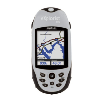
Do you have a question about the Magellan eXplorist 350H and is the answer not in the manual?
Warning against using the navigation device while driving a vehicle.
Emphasizes careful orienteering and good judgment, advising against sole reliance on the device.
Step-by-step instructions for inserting AA batteries into the device.
Instructions for setting the correct battery type for accurate display.
Steps to perform a hard reset if the device becomes unresponsive or erratic.
Use TRACK ME for scouting, tracking hunts, setting cameras, or finding blinds.
Steps to initiate a TRACK ME trip within the HUNT menu.
How to record current location or map spots as waypoints with specific icons.
Steps to pan the map cursor and mark a specific spot as a waypoint.
Function to navigate back to the starting point of a trip using the Backtrack feature.
Procedure for saving a completed TRACK ME trip to the MY TRIPS list.
Create custom trips for navigation, defining routes with waypoints and options.
Use TRACK ME for random hiking to track and record movements.
Steps to initiate a TRACK ME trip within the HIKE menu.
How to record current location or map spots as waypoints with specific icons.
Options to manage device power, including sleep timers and battery type.
Ensuring the correct battery type is set for accurate battery life display.
Setting up an alert for deviating from a planned course by a defined distance.
Configuring alerts for arriving at a destination or leg end.
Setting an alert for crossing a specific distance from the destination.
Setting an alert for approaching a saved waypoint within a defined distance.
| Display Type | Color TFT |
|---|---|
| Display Resolution | 240 x 320 pixels |
| Battery Life | Up to 18 hours |
| Waterproof Rating | IPX7 |
| Map Coverage | Worldwide basemap |
| Battery Type | 2 AA batteries |
| High-sensitivity receiver | Yes |
| Preloaded maps | Yes |
| Ability to add maps | Yes |
| Waypoints/favorites/locations | 500 |
| Area calculation | Yes |
| Picture viewer | No |
| Geocaching-friendly | Yes |
| Track Logs | Yes |
| Barometer | No |
| Interface | USB |
| Display Size | 2.2 inches |
| Expandable Memory | microSD card |
| Operating Temperature | -4° to 140°F (-20° to 60°C) |

