Do you have a question about the Magellan eXplorist GC and is the answer not in the manual?
Covers warnings against using the device while driving and general advice on judgement, care, and accessories.
Step-by-step instructions for replacing the AA batteries in the receiver.
Explains the status bar icons and the main menu screen for device navigation.
Covers map view, panning, smart arrow, and zoom functionality.
Provides detailed information for individual geocaches.
Details accessing and using the main menu and map screen.
Covers map zooming, panning, and creating new waypoints.
Covers creating waypoints from current position and additional routing options.
Instructions for viewing the list of geocaches and specific geocaches on the map.
Accesses options for viewing, sorting, and managing geocaches.
Steps to add a new geocache to the receiver.
Instructions for sending geocaches from the website to the GPS receiver.
Detailed steps for sending geocaches via the website's detail page.
Procedure for installing geocaches by dragging and dropping files.
Guides for uploading field notes and logs from receiver or VantagePoint.
Detailed steps for uploading logs using VantagePoint software.
Procedure for publishing created geocaches to Geocaching.com.
| Outdoor (hiking, trekking) | Yes |
|---|---|
| Marine (chartplotters, sounders) | - |
| Traffic Message Channel (TMC) | No |
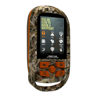
| Form factor | Handheld |
| Product color | Green |
| GPS accuracy - position | 5 m |
| Map coverage | World |
| Display diagonal | 2.2 \ |
| Display resolution | 240 x 320 pixels |
| Internal storage capacity | 2 GB |
| Processor frequency | 400 MHz |
| USB 2.0 ports quantity | 1 |
| USB 3.2 Gen 1 (3.1 Gen 1) Type-A ports quantity | 0 |
| Supported radio bands | Not supported |
| Battery type | AA |
| Power source type | Battery |
| Battery life (max) | 18 h |
| Battery technology | Alkaline |
| Number of batteries supported | 2 |
| Operating temperature (T-T) | -10 - 60 °C |
| Antenna type | Multidirectional Patch |
| Depth | 36 mm |
|---|---|
| Width | 56 mm |
| Height | 111 mm |
| Weight | 147 g |

