Do you have a question about the Navman Tracker 5430 and is the answer not in the manual?
Covers cleaning and maintenance procedures for the TRACKER unit, emphasizing gentle cleaning methods.
Details the types of plug-in cards (C-MAP™ chart, C-MAP™ user) and their functions.
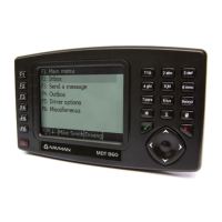
Explains the function of each key on the TRACKER control panel for basic navigation.
Defines 'Press' and 'Hold' actions and explains how to select items and change data.
Explains the typical chart display elements, including data display, boat position, and course information.
Details the two chart modes: 'Centre on boat' and 'Cursor' mode, and how to switch between them.
Explains how latitude and longitude are displayed, showing boat position or cursor position.
Describes how to zoom in/out on the chart and how the chart scale is displayed.
Instructions on how to find and display nearby services like ports and tide stations.
Guides on how to change the numeric data fields and toggle the compass display on the chart.
Explains how to plot a course, calculate leg distances, bearings, and total distance.
Simple navigation guide to go straight to a waypoint or an arbitrary point on the chart.
Explains how to display projected position based on COG, speed, and time.
Details how the TRACKER records and displays the boat's course history (tracks).
Discusses internal and external GPS antennas, compatibility, and optional DGPS antennas.
Explains the typical time it takes for the GPS receiver to acquire a fix upon startup.
Details the waypoints display, listing entered waypoints with their details and display options.
Covers creating, moving, editing, and deleting waypoints and their data.
Covers creating, editing, displaying, and deleting routes, including warnings about land navigation.
Step-by-step instructions for creating new routes from the chart or routes display.
Guides on how to edit existing routes, either directly on the chart or from the routes display.
Explains how to start navigating along a route, skip waypoints, or cancel a route.
Instructions on how to save waypoints, routes, or tracks from the TRACKER to a user card.
Guides on how to load data files (waypoints, routes, tracks) from a user card into the TRACKER.
Instructions on formatting the user card, noting that it erases all data.
System setup options including language, backlight, keybeep, and factory reset.
Chart setup options like rotation, CDI scale, plotter mode, map datum, and map shift.
Details system settings like language selection, backlight/contrast adjustment, and keybeep.
Covers chart setup options: rotation, CDI scale, plotter mode, map datum, and map shift.
Explains map datum selection and map shift for aligning TRACKER positions with paper charts.
Controls how waypoints are displayed on the chart (Hide all, Show all, Selected).
Guides on setting GPS source (Internal, NMEA, NavBus), DGPS source, and restarting the GPS.
Details fuel setup for adding/removing fuel, setting tank full/remaining, and engine configuration.
Explains how to calibrate fuel transducers for accurate fuel measurement.
Covers track setup for recording, display, plotting intervals, and managing track data.
Details log values like trip distance and total distance, and how to reset them.
Setup for various alarms: arrival radius, anchor, XTE, danger, low fuel, and DGPS alarm.
Configuration for units of measurement for distance, speed, depth, fuel, and compass.
Configuration for simulate mode, including normal/demo mode, speed, and heading.
Details the NavBus system for connecting instruments, shared settings, and alarms.
Explains NMEA standards for interfacing marine electronics and TRACKER's NMEA capabilities.
Lists the standard components included with the TRACKER unit in its configuration.
Details optional accessories and kits available for the TRACKER, like chart cards and fuel kits.
Provides detailed installation instructions for the display unit, GPS antenna, and optional fuel kit.
Instructions for mounting the display unit, including flush and bracket mounting arrangements.
Guidance on fitting and wiring GPS antennas, including internal and external options.
Details on wiring the power supply, including fuse requirements and connections.
Describes basic wiring options for powering the TRACKER, including manual power-on.
Explains auto power wiring, enabling the TRACKER to turn on/off with the boat's ignition.
Detailed pinout and signal description for the power/data cable.
Wiring diagram and instructions for basic power connection to the TRACKER 5430.
Details physical dimensions, display resolution, and build characteristics of the TRACKER.
Information on compatible C-MAP™ chart and user card types.
Details NMEA 0183 compatibility, input/output sentences, and required cables.
Troubleshooting steps for when the TRACKER unit fails to power on.
Diagnoses and solutions for lack of GPS signal or slow fix acquisition.
Troubleshooting steps for issues related to DGPS fix acquisition or loss.
Troubleshooting for inaccurate fuel consumption readings, checking wiring and refuelling.
Definitions of technical terms used throughout the TRACKER manual.
| Display Resolution | 480 x 272 pixels |
|---|---|
| Touchscreen | Yes |
| Waterproof | No |
| Text-to-Speech | Yes |
| Battery Life | Up to 3 hours |
| Resolution | 480 x 272 pixels |
| Maps | Preloaded Australia & New Zealand |