Do you have a question about the Parrot ANAFI USA GOV and is the answer not in the manual?
Guidance on how to use the user manual effectively and find information.
Lists additional documentation resources for the ANAFI USA drone.
Steps to wake up, charge, and prepare the smart battery for use.
Powering on the controller, connecting to network, and software updates.
Instructions to launch the FreeFlight 6 piloting application on the controller.
Details the procedure for updating the controller and drone software.
Instructions for safely taking off the ANAFI USA drone from various surfaces.
Procedures and considerations for deploying the drone from a moving vehicle.
General guidance and controls for flying the ANAFI USA drone.
Overview of different piloting modes available in FreeFlight 6.
Accessing and configuring various settings to customize drone operation.
Manual controls for exposure, shutter speed, ISO, and white balance.
Accessing and utilizing the drone's thermal imaging capabilities.
Planning and executing flights using map-based features.
Guide on converting GeoTIFF maps for use with ANAFI USA.
Solutions for common issues encountered with the drone.
A checklist for pre-flight preparation and operational readiness.
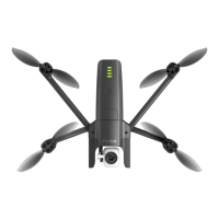
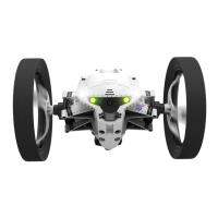
General information about the ANAFI USA drone's design and limitations.
Explanation of GPS functionality and recommended video settings.
Information on the drone's smart battery, installation, and handling.
Details on the battery's wintering mode for extended storage.
Explanation of the automatic return-to-home feature and its configuration.
Essential warnings regarding age, hazards, and responsible drone operation.
Detailed technical specifications for the ANAFI USA drone.
Technical details for EO and IR image chains and stabilization.
Specifications for the fast-charging smart battery and Skycontroller USA.
A comprehensive list of all components included in the ANAFI USA package.
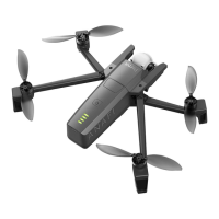
Illustrates the drone's foldable arms for portability and storage.
Highlights key features for immediate flight readiness.
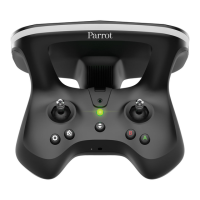
Identification of main controls and buttons on the Skycontroller USA.
Description of functions for buttons and triggers on the controller's top panel.
Explanation of LED color and pattern meanings for the controller.
Steps to enter maintenance mode for data access and updates.
Instructions for finding media and installing custom maps.
Step-by-step guide to pair the ANAFI USA drone with its controller.
Ensuring all equipment and software are updated and ready.
Verifying regulations, Wi-Fi, weather, and flight zone safety.
Comprehensive steps for preparing the drone and controller for initial flight.
Instructions for taking off the drone from a flat, clear surface.
Detailed instructions and safety warnings for launching the drone by hand.
Important points and safety tips for deploying the drone from a moving vehicle.
Specific steps for performing a hand launch from a moving vehicle.
Procedure for performing a standard take-off from a moving vehicle.
How the left joystick controls ascent, descent, and rotation.
How the right joystick controls forward, backward, and lateral movement.
Adjusting speed and inclination for optimal flight time or distance.
Tips for maintaining a stable Wi-Fi connection between drone and controller.
Initiating the return-to-home function for the drone.
Setting a precise home point for improved return-to-home accuracy.
Explanation of the Smart Return-to-Home feature and its advanced settings.
Displaying, setting, and managing geographical coordinates in FreeFlight 6.
Selecting different coordinate systems (LATLNG, MGRS, UTM, DMS).
Opening the full-screen map view in FreeFlight 6.
Copying coordinates from the map for RTH or other uses.
Choosing how coordinates are displayed (Reticle, Drone, Dynamic).
Using controller options to share coordinate information.
Configuring advanced RTH features like Pilot and Custom RTH.
Returning the drone to the controller's last known GPS position.
Setting a custom return-to-home destination using map coordinates.
Displaying and setting the initial home point for the drone.
Activating and dragging the home icon to define a custom RTH point.
Preparing the drone for a standard landing on a flat surface.
Detailed instructions for safely landing the drone by hand.
Step-by-step guide for safely recovering the drone from a moving vehicle.
Instructions and diagrams for replacing damaged propeller blades without tools.
Correct procedures for installing and removing the drone's smart battery.
Procedures for charging the smart battery using various power sources.
Explanation of how the battery's LEDs indicate charge level.
Instructions on how to update the smart battery's firmware.
Guidelines for storing the battery to maximize lifespan and durability.
Steps to perform a hard reset on the smart battery for troubleshooting.
Step-by-step guide for inserting a microSD card into the drone.
Methods for transferring media files from the drone to a computer.
Accessing media directly from the drone using a USB connection.
Managing and previewing media files within the FreeFlight 6 application.
Procedure for formatting the microSD card for use with the drone.
Process for encrypting the microSD card for enhanced data security.
Steps to share the drone's video stream using VLC media player.
Introduction to the piloting software, its features, and the Heads-Up Display.
Explanation of the various components displayed on the video mode Heads-Up Display.
List of piloting modes: Manual Flight, Cameraman, Follow Me, etc.
List of video modes: Standard, Cinema, Hyperlapse, etc.
Description of the components displayed on the photo mode Heads-Up Display.
Settings for controller behavior and activating features like Hand-launch.
Adjusting flight behavior for different modes (FILM, SPORT, RACING).
Adjusting speed and inclination for optimal flight dynamics.
Settings for thermal camera color gradient, post-processing, and temperature range.
Steps for calibrating the thermal camera for accurate readings.
Options to disable drone LEDs and the RTH function.
Customizing the information displayed on the drone's HUD.
Available options when using the Light interface on the HUD.
Setting Geofence, max altitude, max distance, and RTH behavior.
Configuring the drone's behavior at the end of an RTH sequence.
Settings for camera calibration, auto-record, overexposure, and anti-flickering.
Changing Wi-Fi network name, password, and band settings.
Information on the drone's DRI system for regulatory compliance.
Steps to connect external antennas to the Skycontroller USA.
Procedures for activating external antennas and switching back to the internal one.
Introduction to video recording features and configurable settings.
How to select video modes and confirm choices via the HUD.
Details on slow-motion and high-framerate video recording.
Interface for selecting standard video resolutions and frame rates.
List of image formats: JPEG RECT, JPEG WIDE, DNG+JPEG.
How to access and select photo modes like Single, Burst, Timer, Panorama.
Step-by-step guide to choose desired photo formats within each mode.
HUD feedback for single, burst, and bracketing photo modes.
HUD feedback for timer, timelapse, and GPS lapse photo sequences.
The three phases involved in automatically generating a panorama.
Important guidelines to follow before shooting a panorama.
Details on photos and time for different panorama types.
How to download panorama photos to the Skycontroller USA.
Accessing downloaded panorama media from the local gallery.
Options for generating panoramas at different resolutions.
Creating sphere panoramas and various custom panorama types.
How to operate the gimbal tilt using the controller's left trigger.
How to operate the zoom function using the controller's right trigger.
Demonstrates the drone's view at the 1x zoom level.
Shows the drone's view at the 5.3x zoom level.
Illustrates the drone's view at the maximum 32x zoom level.
Steps to correct a tilted horizon in the drone's camera feed.
Shows the initial state of the camera calibration screen.
Shows the state after applying horizon correction.
Steps to align visible and thermal camera images.
How to adjust the exposure value for photos and videos.
Understanding and setting shutter speed for optimal image capture.
How ISO sensitivity affects image quality and how to adjust it.
Adjusting white balance for accurate color representation in different lighting.
Various white balance presets available for different lighting conditions.
How to use High Dynamic Range to enhance photos and videos.
How to turn the HDR feature on and off.
Available styles like Natural, P-LOG, Intense, and Pastel for image processing.
Settings for Saturation, Contrast, and Sharpness to fine-tune image appearance.
How to lock auto exposure to maintain consistent exposure in a shot.
How to lock exposure on a specific point for precise control.
Introduction to thermal imaging and its applications with ANAFI USA.
Explanation of the Heads-Up Display elements for thermal imaging.
Default thermal mode providing a quick overview of temperature ranges.
Available photo and video modes within the Thermal Spectrum.
Using Spot Thermal mode to highlight specific temperature areas.
Using the analyzer for quick thermal analysis on photos and videos.
Accessing and selecting automated cinematic shots.
Capturing a full 360-degree panorama by rotating the drone.
Drone movement and camera tilt for a scenic reveal shot.
Drone movement and camera rotation for a spiral effect shot.
Drone moves backward while keeping subject centered for a dramatic effect.
Default mode for direct drone and camera control.
Orbiting around a selected subject while keeping it centered.
How to activate Follow Me mode and its GPS requirements.
Different tracking modes: Track, Lock, Dynamic.
Special automated flight patterns for selfies or group shots.
Drone flies away and returns, following a specific path.
Introduction to Smartdronies like Orbit, Parabola, and Dolly Zoom.
Steps to upload DTED maps for terrain height data in CoT.
Detailed steps for transferring and loading DTED files onto the controller.
Defines map outline colors indicating saved location and map types.
Procedure to remove previously uploaded maps from the controller.
How to enable or disable the Cursor on Target feature.
Explains the three elements added to the FreeFlight 6 HUD by CoT.
How CoT information appears on screen for drone and controller references.
Switching the reference point between the drone and the controller.
Switching between horizontal/vertical and slant distance displays.
Functions of the coordinate display lock and calibration buttons.
Button to switch between drone and controller references.
How calibration improves location measurement accuracy.
Positioning the drone in the correct zone for calibration.
Validating calibration and important notes on accuracy.
Limitations of using FLAT maps for CoT accuracy.
Factors influencing the accuracy of CoT measurements.
How map type and terrain relief affect CoT accuracy.
Modifying parameters like coordinates system and time zone for CoT.
How to capture screenshots with telemetry and CoT data.
Introduction to automated flight planning using maps.
How the map interface opens for flight planning.
Example of starting a new flight plan.
How to set the first waypoint and its parameters.
Adjusting the camera direction at the initial waypoint.
Setting a second waypoint and its altitude.
Creating a POI to keep the camera focused during flight.
Linking waypoints to follow a POI.
Visual representation of waypoints linked to a POI.
Confirming POI flight plan choices and starting the flight.
Modifying waypoint height and camera direction.
Drone behavior upon completion of the flight plan.
Safety warnings for executing flight plans.
Flying the drone to a selected point on the map.
Flying around a selected Point of Interest.
How to stop or reset a POI in Touch & Fly mode.
Activating Smartdronies for a POI.
Using QGIS software to convert GeoTIFF maps to PNG tiles.
Accessing the Processing Toolbox within QGIS.
Starting the gdal2tiles process for map conversion.
Selecting output directory and zoom level for converted maps.
Compressing converted map folders and copying them to the controller.
Reference to the section for Skycontroller USA Maintenance Mode.
How the new map appears as an overlay on the default map.
Procedure to reset the drone's firmware to its original state.
Steps to perform a hard reset on the drone's smart battery.
Steps to reboot all drone systems to resolve connectivity issues.
Guide to pair the ANAFI USA drone with its controller.
Steps to take if the drone does not power on.
Troubleshooting steps for unexpected battery behavior.
Reasons and solutions if the drone won't take off.
Cause and fix for the drone flipping over during take-off.
Steps after a crash: checks, calibrations, and contacting support.
How to set FreeFlight 6 as the default application on the controller.
Checklist for ensuring software and calibration status is up-to-date.
Pre-flight checks for drone and controller when powered off.
Checks to perform when the drone and controller are powered on.
Essential checks before the drone takes off.
Checks to perform after the drone has taken off.
Checks to perform before landing the drone.
Steps to follow after the drone has landed and is powered off.
| Aircraft Type | Quadcopter |
|---|---|
| IP Rating | IP53 |
| Battery Chemistry | LiPo |
| Maximum Bitrate | 100 Mbps |
| Flight Time | 32 minutes |
| Operating Temperature | -10°C to 40°C |
| GPS | Yes |
| Charging Time | 90 min |
| Hovering Accuracy (Vertical with GPS) | 0.5 m |
| Camera Sensor | 1/2.4" CMOS |
| Photo Format | JPEG, DNG |
| Gimbal | 3-axis |
| Camera Resolution | 21 MP |
| Frequency Band | 2.4 GHz, 5 GHz |
| Focal Length | 24 mm |