EasyManua.ls Logo

Pentax R-425VN User Manual

Pentax R-425VN
142 pages
To Next Page IconTo Next Page
Page #1 background imageLoading...
Page #1 background image
ToTal STaTion
INSTRUCTION
MANUAL
PowerToPoliTe
FOR R-400V SERIES
R-422VN
R-423VN
R-425VN
R-435VN
TI Asahi Co., Ltd.
International Sales Department
3F AUM Bldg. 3-37-14,
Hazawa, Nerima-Ku
Tokyo, Japan 176-0003
Tel: +81-3-5912-7072
Fax: +81-3-5912-7074
E-mail: international@tiasahi.com
r-400V
SERIES

Table of Contents

Question and Answer IconNeed help?

Do you have a question about the Pentax R-425VN and is the answer not in the manual?

Pentax R-425VN Specifications

General IconGeneral
TypeTotal Station
Magnification30x
Angle Accuracy5"
Internal Memory10, 000 points
CommunicationRS-232C
Water ResistanceIP54

Summary

Accessing PowerTopoLite Features

File Management Operations

Measure Functionality

Station Setup by Rectangular Coordinates

Guides setting up the station point using rectangular coordinate input.

Station Orientation

Explains how to orient the station by setting horizontal angles and backsight points.

Station Setup by Polar Coordinates

Guides setting up the station point using polar coordinate input.

Measure Screen Functions

Station Setup: Rectangular & Polar Coordinates

Station Orientation Procedures

Measure Screen Display Options

View and Edit Data

Free Stationing Operations

Stationing with More Than 3 Known Points

Explains how to determine the station point using more than three known points.

Stationing with Two Known Points

Details the procedure for determining station coordinates using only two known points.

Stake Out Functionality

Stake Out Procedure

Guides the process of staking out points based on known station and direction angles.

Stake Out: Point to Line

Stake Out: Point to Arc

Calculation Functions

COGO Calculations

Introduces the Coordinate Geometry (COGO) functions available for calculations.

Inverse Calculation

Explains how to calculate direction angle and distance between two known points.

Point Coordinates Calculation

Circle Radius Calculation

Line-Arc Intersection Calculation

Line-Line Intersection Calculation

Arc-Arc Intersection Calculation

Distance Offset Calculation

Point Distance Offset Calculation

Arc Distance Offset Calculation

2D Surface Area Calculation

3D Surface and Volume Calculation

Remote Elevation Measurement (REM)

Virtual Plane Measurement (VPM)

Remote Distance Measurement (RDM)

Traverse Calculations

Start Point Measuring

Explains how to start a new traverse measurement by defining the start point.

Traverse Calculation

Describes performing traverse calculations (fixed, closed, open).

Input and Output Operations

Communication via USB

Details connecting the instrument to a PC via USB for data transfer.

Communication via COM Port

Explains data transfer using the COM port connection.
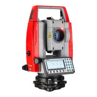
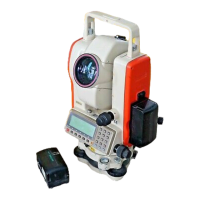
Preference Settings

Related product manuals