Do you have a question about the Raymarine Pathfinder Radar and is the answer not in the manual?
Introduction to the hsb2 (PLUS) series display systems and their components.
Overview of the Pathfinder Radar PLUS display features and operations.
Overview of the chartplotter capabilities and display features.
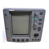
Description of the display unit's controls, including trackpad, keys, and menus.
Instructions for powering the display unit on, off, and managing modes.
Methods for controlling the display modes and window configurations.
Using radar display controls like zoom, offset, and hiding the heading marker.
Functions for navigating and manipulating the chart display.
How to select and change the radar's range scales for optimal viewing.
Guidance on understanding radar echoes and adjusting picture settings.
Detailed steps for manually adjusting radar gain, clutter, and tuning controls.
How to improve target visibility using interference rejection, expansion, and wakes.
Using Variable Range Markers (VRMs) and Electronic Bearing Lines (EBLs) for measurements.
Procedures for setting up guard zones and managing associated alarms.
Introduction to the MARPA function for target tracking and collision avoidance.
How to select and change radar heading modes (Head Up, North Up, Course Up).
Procedure for initiating and using the Man Overboard (MOB) function.
Instructions for inserting and removing C-MAP NT chart cards.
Guidance on placing, selecting, editing, and erasing waypoints.
Detailed steps for placing waypoints using cursor or list methods.
Instructions for modifying waypoint symbols, names, and positions.
Procedures for deleting waypoints, including those used in routes.
Guidance on creating, saving, clearing, and managing routes.
Steps to create a new route by placing or selecting waypoints.
Guidance on following routes, arriving at waypoints, and navigating to points.
Using VRM/EBL to accurately measure distance and bearing between points.
Setting up and managing various chartplotter alarms and timers.
Procedure for initiating and using the Man Overboard (MOB) function on charts.
Information and setup for GPS tracking, satellite status, and differential GPS.
Instructions for accessing and modifying system, radar, MARPA, and chart parameters.
Detailed list and descriptions of system parameters and their default settings.
Parameters for configuring radar display settings and preferences.
Options for specifying MARPA target vectors, safe zone, and history.
Chartplotter configuration options for display preferences and features.
Instructions for mounting the display unit using brackets or flush mounting.
Guidelines for grounding, DC power, and connecting external equipment.
How to connect the scanner to the display unit using inter-unit cables.
Procedures for testing the radar installation and performing alignment.
Steps for powering on the unit and performing initial setup and alignment.
Procedure to check and adjust the radar bearing alignment for accuracy.
Connecting and integrating the display with other equipment via HSB, SeaTalk, NMEA.
Performing checks to ensure correct operation of integrated systems.
Information on routine maintenance procedures and safety guidelines.
Information on performing factory, power-on, and picture resets.
Identifying common problems and their solutions for the display unit.
Information on how to contact Raymarine for technical assistance.