Do you have a question about the Samyung NF700 and is the answer not in the manual?
Procedure for cleaning the chart plotter screen carefully to avoid damage.
Instructions for installing the chart plotter using bracket or flush mounting.
Explanation of the function of each button on the unit and remote control.
Using the MOB feature for immediate location marking.
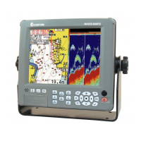
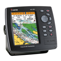
Displaying navigation data on preloaded maps, including buoys, depth, etc.
Instructions for navigating directly to a stored waypoint or cursor location.
Procedures for navigating a pre-defined sequence of waypoints (routes).
Activating and interpreting the sonar function for fish finding and depth detection.
Managing waypoints, including creating, moving, editing, and deleting them.
Creating, managing, and navigating routes composed of multiple waypoints.
Configuring system-wide settings like language, chart source, and beep volume.
Customizing chart display options, rotation, palette, and map datum.
Adjusting sonar parameters like frequency, palette, scroll speed, and advanced settings.
Configuring GPS source, DGPS, static navigation, and magnetic variation.
Setting up track recording, display options, and managing logs.
Managing user data, including saving, loading, deleting, and formatting.
Filtering AIS vessels, setting alarms, and configuring display options.
Setting up various alarms for fish, depth, temperature, navigation, and system status.
Diagrams and pinouts for connecting power, GPS, sonar, and radio devices.
Connecting sonar transducers and optional speed/temperature sensors.
Initial setup procedures, chart card insertion, and GPS satellite acquisition check.