Page 18 of 40
2017-05-23
CU-M001 User manual
loss of boTTom Track/open ocean
If the bottom track is lost, normally due to depth outside of the range of the vessel, the system will
put dashes into the areas with no data. If water current is selected and both GPS and heading are
input, the current will use these data for compensation. If not, this parameter will not be available.
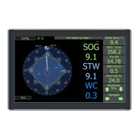
display of boTTom Track from gps
If this function is enabled, the unit can be made to replace SOG information on screen with information
derived from GPS and heading. This information is not given out from the units communication
system, as it is not generated from this unit.(MED regulations) if GPS data is inuse for all or part of
the calculation of the displayed data, a symbol will be displayed by the effected data
surface currenT measuremenT
Surface current is measured in the water track cell.(1-3m distance from sensor)
This cell size may vary in different water depth conditions, but it is shown on the depth display.
Surface current has its own separate display allowing the user to adjust some of the parameters.
• Temperature: is measured at the water boundary, with in the sensor, its data is used
internally to compensate for sound speed
• Tilt, is measured in the sensor, and is used internally for quality control of data
• Depth, is measured from all beams. These beams are slanted at approx. 30 degrees and
will therefore not measure directly underneath the vessel. For this reason, they cannot
be used as an approved sounder. However they cvan be ouput as a PSKPDPC NMEA
message
The Trip values measures the distance travelled through water. The total is the distance since system
installation, the trip can be reset to show daily trip or service intervals. If presented in an information
the trip can be reset by pressing and holding the Trip information, otherwise the trip reset can be
found in the DL setup menu. Trip can also be reset remotely as required in some standards, from
SKIPPER multirepeaters, or by NMEA command
The Total value is the total distance sailed through water (using the STW value that should always
be present) This value cannot be reset except by qualied service personel. This system does not
measure distance over ground as this number will not be correct as the vessel will stop measuring
the distance when the bottom is lost