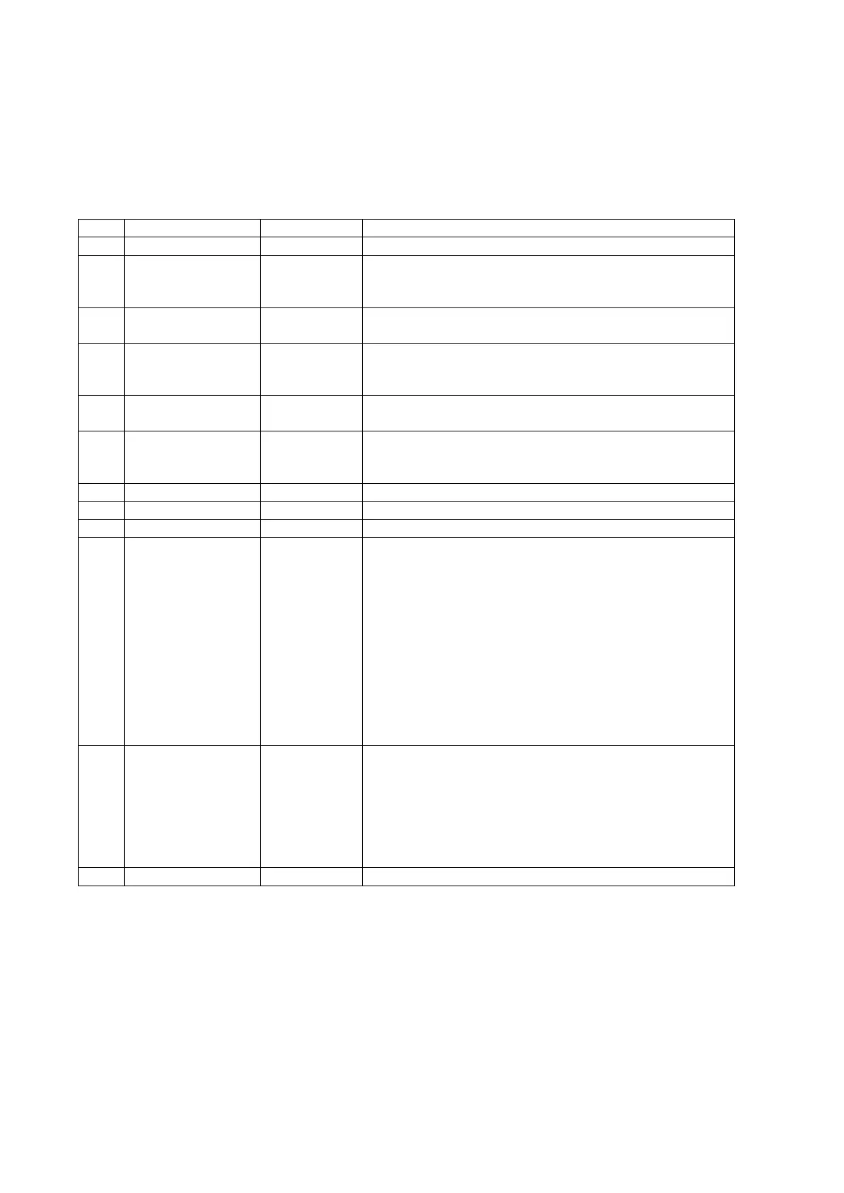
21
Time, date, position, course and speed data provided by a GNSS navigation receiver.
Structure:
$GPRMC,hhmmss.sss,A,dddmm.mmmmmmm,a,dddmm.mmmmmmm,a,x.x,x.x,ddmmyy,,,a,a*hh<CR><LF>
1 2 3 4 5 6 7 8 9 10 11 12
Example:
$GNRMC,072120.000,A,2447.0913289,N,12100.5212111,E,000.0,000.0,050721,,,R,V*14<CR><LF>
UTC time in hhmmss.sss format (000000.00 ~ 235959.999)
Status
‘V’ = Navigation receiver warning
‘A’ = Data Valid
Latitude in dddmm.mmmmmmm format
Leading zeros transmitted
Latitude hemisphere indicator
‘N’ = North
‘S’ = South
Longitude in dddmm.mmmmmmm format
Leading zeros transmitted
Longitude hemisphere indicator
‘E’ = East
‘W’ = West
Speed over ground in knots (000.0 ~ 999.9)
Course over ground in degrees (000.0 ~ 359.9)
UTC date of position fix, ddmmyy format
Mode indicator
‘A’ = Autonomous mode
‘D’ = Differential mode
‘E’ = Estimated (dead reckoning) mode
‘F’ = Float RTK. Satellite system used in RTK mode, floating
integers
‘M’ = Manual Input Mode
‘N’ = Data not valid
‘P’ = Precise
‘R’ = Real Time Kinematic. System used in RTK mode with fixed
integers
‘S’ = Simulator Mode
Navigation status indicator according to IEC61108 requirement
on ‘Navigational (or Failure) warnings and status indicators’.
‘S’ = Safe
‘C’ = Caution
‘U’ = Unsafe
‘V’ = Navigation status not valid, equipment is not providing
navigation status indicator.
VTG – Course Over Ground and Ground Speed
The actual course and speed relative to the ground.