Do you have a question about the Avidyne Entegra EX5000 and is the answer not in the manual?
Explains the bezel controls on the EX5000 MFD for accessing information and navigating functions.
Details the EX5000's hardware self-test, initialization process, and startup page display with database currency.
Details controls for sensor modes (Radar, WX Rprts, Lightning) and mapping functions (View, Declutter, Base Map).
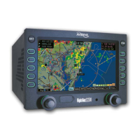
Describes symbols used on the map page for terrain, aircraft position, and navigation aids.
Details symbols for airport runways, flight plans, ownship position, and traffic indications on the map display.
Explains how to control the map's orientation, such as North-Up or Track-Up, relative to the aircraft nose.
Details errors that can occur on the Map page, including loss of GPS and heading input.
Outlines the settings for the Traffic page, which is a configured Map page for traffic display and situational awareness.
Explains the three symbols used to display aircraft traffic detected by a Traffic Sensor, including TIS systems.
Details the status indicators for TIS installations reported in the Traffic status block.
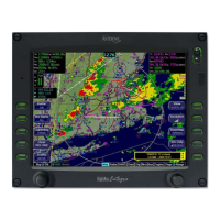
Explains how radar data is overlaid on the Map page for integrated weather and navigation views.
Explains how to access and operate the dedicated Radar page, including controls for tilt, bearing, and gain.
Details how to operate the radar in Ground Mode, including ON, Test, and Standby functions for pre-takeoff checks.
Discusses specific issues and features when using Bendix-King ART-2000 or ART-2100 radar with the EX5000.
Provides critical safety information and warnings about microwave energy exposure from aircraft weather radar.
Details the TAWS display, including hazard alerts (yellow/red) and its role in enhancing situational awareness.
Explains the two levels of TAWS alerts (Caution, Warning) and how they are displayed for terrain or obstacle conflicts.
Provides reference information for TAWS features like Auto-Range, Simultaneous Alerts, and error indications.
Explains the validity period of CMax charts and how expired charts are displayed with a watermark.
Explains how European VFR Charts can be included in the CMax subscription and accessed.
Provides an overview of CMax charts, their content, subscription requirements, and data loading instructions.
Explains the benefit of geo-referenced charts for displaying ownship symbol and flight plan legs accurately.
Describes how to access the CMax Chart page and its default behavior upon startup.
Explains how charts are divided into sections and the use of Display and View buttons for different chart views.
Details the views for Procedure charts (Header, Profile, Minimums) and their preview pane functionality.
Lists the available views for Airport charts: Plan, Header, Runways, and Departure.
Describes the CMax Selection Page for choosing charts, including the chart selection list and chart NOTAMs.
Details how to use the Airport Selection page to specify airport charts and runway information.
Displays chart NOTAMs associated with the currently displayed airport.
Describes the main Aux page for viewing messages and accessing setup menus like Airport Filter and System Time.
Details how to set criteria for nearest airport searches, including type, surface, and runway length.
Defines navigation symbols and display settings, allowing selection of VFR/IFR defaults or individual item display.
Covers editing data blocks in the Map page corners to display available data types like engine or navigation data.
Allows setting the time zone offset, menu timeout, and verifying time/date for Datalink weather accuracy.
Explains the CMOS battery's function for maintaining system time and how to operate the MFD without it.
Allows setting Datalink options like coverage area, radius, and radar resolution.
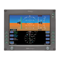
Outlines the main sections of the Engine page: Gauges, Vacuum, Electrical, and Fuel, plus OAT gauge.
Details the PA34's twin-engine gauges, including manifold pressure, RPM, oil temp, and fuel data.
Explains how to input the initial usable fuel amount for the PA34 aircraft tanks on startup or via the Initial Fuel button.
Guides users through the Lean Assist function for setting optimum mixture for PA34 cruise conditions.
Details configuring data blocks on the Map page to display PA34 engine instrument information.
Explains EMax feature for real-time recording and downloading of engine performance data.
Displays gauges and data for the PA46 Meridian engine, including torque, ITT, RPM, and fuel.
Explains how to input the initial usable fuel amount for the PA46 Meridian aircraft tanks.
Details configuring data blocks on the Map page to display PA46 Meridian engine instrument information.
Displays gauges and data for the PA46 Mirage engine, including manifold pressure, RPM, oil temp, and fuel.
Explains how to input the initial usable fuel amount for the PA46 Mirage aircraft tanks.
Guides users through the Lean Assist function for setting optimum mixture for PA46 Mirage cruise conditions.
Details configuring data blocks on the Map page to display PA46 Mirage engine instrument information.
Details the EX5000's support for Broadcast Datalink receivers like ADS-B FIS-B and XM receivers.
Explains how the Broadcast Datalink receiver continuously receives weather data and how to control its display.
Describes how the EX5000 displays weather data, covering Text METARs and Graphical METARs.
Explains symbols used for Broadcast Datalink, including lightning, METARs, AIRMETs/SIGMETs, Radar, Storm Cells, and TFRs.
Explains how the EX5000 uses buttons and WX Reports when no traffic sensor or radar is installed.
Shows how the Nearest page displays METAR information received via Datalink, including symbols and text.
Details how the Trip page displays weather information from Datalink, associated with METAR points and intermediate waypoints.
Details how to update NavData, CMax Chart Data, and download EMax data from the EX5000.
Guides users on logging in to activate service for XM Radio and obtaining necessary information.
Provides instructions and materials for cleaning the EX5000 screen safely to prevent scratches and damage.
Explains the symbols used in the Sensor Status Block to indicate the status of traffic and lightning sensors.
Details symbols used on the EX5000 Map page for airports, navaids, airways, airspace, and obstacles.
Describes the line styles used for airspace, airways, and TFR status lines on the map display.
Lists and describes available data types that can be displayed in the data blocks on the Map page.
Lists TAWS messages, their meanings, and recommended pilot actions for obstacle and terrain cautions/warnings.
Details navigation messages, their meanings, and recommended pilot actions for GPS/FMS validity and communication issues.
Lists traffic messages, their meanings, and recommended pilot actions for traffic sensor status and advisories.
Provides a list of lightning messages, their meanings, and recommended pilot actions for lightning sensor status and faults.
Lists engine messages, their meanings, and recommended pilot actions for parameter deviations.
Details PFD messages, their meanings, and recommended pilot actions for PFD operational status.
Lists broadcast datalink messages, their meanings, and recommended pilot actions for receiver and data reception issues.
Lists radar messages, their meanings, and recommended pilot actions for radar system errors and failures.
Provides a glossary of common avionics abbreviations used throughout the manual.
Lists features like Obstacle Display, TIS Traffic, and TFRs that are generally only available within the United States.
Notes that XM WX Weather and EX5000 Datalink features are not currently available outside North America.
Explains that CMax chart availability depends on subscription coverage and provides contact info for questions.