Do you have a question about the Canon GP-E1 and is the answer not in the manual?
Explains how the receiver geotags shots with location and direction data, viewable on a map.
Explains the meaning of symbols used within the manual for warnings and supplemental information.
Outlines the basic assumptions made about the camera and receiver setup for manual operations.
Lists critical warnings to prevent fire, explosion, injury, or death during use and handling.
Details precautions to prevent equipment damage or personal injury, including heat and chemical risks.
Provides guidance on handling the receiver, referring to the camera's manual for specific care instructions.
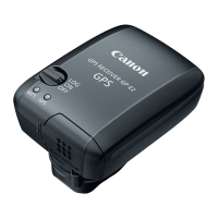
Identifies and labels the physical parts of the GPS receiver and its accessories.
Illustrates the camera's rear LCD panel display relevant to GPS device connection and status.
Step-by-step instructions for securely attaching the GPS receiver to the camera.
Instructions for safely removing the GPS receiver from the camera.
Guides users on how to access and select GPS device settings on the camera menu.
Details the process of enabling the GPS device function within the camera settings.
Explains how to interpret the GPS signal status displayed on the camera's LCD.
Guides users to the GPS device settings menu to configure positioning intervals.
Instructs to enable the GPS device before setting the positioning interval.
Details how to choose the frequency for updating the GPS position.
Allows users to select specific time intervals (e.g., every second, every minute) for position updates.
Guides users to the GPS device settings menu for compass configuration.
Instructs to enable the GPS device before configuring the digital compass.
Details how to enable the digital compass feature within the camera's GPS settings.
Explains how to view the camera's direction using the compass display during shooting.
Guides users to GPS device settings to configure automatic time synchronization.
Instructs to enable the GPS device for automatic time setting.
Details how to select the automatic time update or manual set option.
Advises users on legal restrictions and careful usage of GPS functions in different regions.
Warns about privacy implications of sharing geotagged images and location data.
Notes that GPS signal reception can take time and warns about interference from magnetic fields.
Lists the software included on the solution disc, such as Map Utility and the instruction manual.
Explains that Map Utility displays shooting locations and directions on a virtual map.
States that ImageBrowser EX can update Map Utility and provides information on its features.
Lists the compatible camera model and the types of geotagging information captured.
Specifies the reception frequency and available position update timing options.
Details the camera time adjustment method and the sensors used for the digital compass.
Describes the power source and the estimated number of shots per battery charge based on timing.
Lists physical dimensions, weight, operating temperature, and humidity requirements.
Mentions the included software, ImageBrowser EX and Map Utility.
| Interface | - |
|---|---|
| Sensitivity | - dBmW |
| Channels quantity | - channels |
| Product color | Black |
| Weight | - g |
|---|