Do you have a question about the Clarion MAP670 and is the answer not in the manual?
Details the physical buttons on the Clarion device and their functions.
Describes various on-screen controls like selectors, sliders, and switches.
Explains the on-screen keyboards for data entry, including ABC and QWERTY layouts.
Describes the primary screen for accessing program functions and navigation.
Provides information about software licenses, creators, and legal aspects.
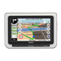
Introduces the map display, its general characteristics, and view modes.
Displays received data from the GPS device, including satellite status.
Describes the Map and Cockpit screens used for navigation and data display.
Displays detailed information and options for the current route planning.
Accesses frequently used program functions like Find, Quick, and Route.
Explains how Clarion uses TMC for real-time traffic updates and rerouting.
Information about warnings for speed and red light cameras.
Basic settings for the Clarion navigation system, including safety mode.
Adjusts appearance parameters of the maps, like color profiles and labels.
Configures audio settings, including master volume and voice guidance.
Defines parameters for route calculation, including method and road types.
Sets program language, voice language, units, and date/time formats.
Accesses advanced settings and special functions for display and behavior.
Fastest way to find a destination and start navigation from the Main menu.
Sets destination by tapping directly on the map and using the Cursor menu.
Accesses location selection possibilities via Main or Menu buttons.
Module for searching locations by address components like city or street.
Accesses previously used locations from the history list.
Enters destination using latitude/longitude coordinates.
Searches for Points of Interest using categories and location reference.
Navigates to pre-set Home or Work destinations with a single tap.
| Resolution | 800 x 480 pixels |
|---|---|
| Bluetooth | Yes |
| Voice Guidance | Yes |
| Touch Screen | Yes |
| SD Card Slot | Yes |
| USB Port | Yes |
| AM/FM Radio | Yes |
| Built-in Microphone | Yes |