Do you have a question about the Garmin GPSMAP 3006C, 3010C and is the answer not in the manual?
Guide for installing the GPSMAP 3006C/3010C unit and associated hardware.
Manual organization and overview of sections to help users understand the unit's operation.
Instructions for registering the product online to help Garmin provide better support.
Contact information and support channels for Garmin product inquiries and assistance.
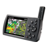
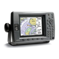
Identifies the main components and features of the GPSMAP 3006C/3010C unit.
Explains the function of each key on the GPSMAP 3006C/3010C keypad.
Details how to operate the GPSMAP 3006C/3010C using the optional remote control.
Explains the function and usage of soft keys located at the bottom of the display.
Describes the information displayed on the status bar, including device status and alarms.
Step-by-step instructions for powering on and initializing the GPSMAP 3006C/3010C unit.
How to adjust the screen brightness using the POWER/BACKLIGHT key.
Process of the GPSMAP 3006C/3010C acquiring satellite signals for navigation.
Instructions for using Simulator Mode for practice when satellite signals are unavailable.
Explains basic terms like highlight, field, soft keys, and on-screen buttons.
Guide on how to select options, enter data, and use the ROCKER and ENTER keys.
How to use the map pointer to pan, select items, and review location data on the map.
Procedure for searching and locating waypoints, anchorages, cities, and other map items.
Methods for creating, marking, and manually entering waypoints.
How to modify, rename, move, or delete waypoints using the Review Waypoint Page.
Explains how to use Go To Point, Follow Track, TracBack, and Follow Route functions.
Steps for creating, copying, deleting, editing, and planning routes.
Entering trip data like speed, departure time, and fuel flow for route planning.
Describes the default and optional main pages available on the GPSMAP 3006C/3010C.
How to customize main pages by adding/removing functions and adjusting data fields.
How to add, cycle through, and adjust function windows on the main pages.
How to display a main page without functions or status bar for a full-screen view.
Displays satellite acquisition, receiver status, and accuracy information.
Provides tide and current information, including graphical charts and station data.
Shows celestial data for sun and moon rise/set, moon phase, and sky view.
Displays trip data such as odometer, average speed, and total time.
Accesses current weather, forecast, sea surface, and marine bulletins.
Manages waypoints, including user and proximity lists and alarms.
Lists and manages available routes for navigation.
Manages track logs, including recording, saving, and viewing track data.
Controls and sets up DSC features for distress calls and position reporting.
Transfers waypoints, routes, and tracks to and from a data card.
Displays a list of messages generated by the unit, with detailed information.
Defines and configures system, navigation, sonar, and weather alarm settings.
Controls system settings like mode, units, time, communications, and updates.
Shows connected devices and allows naming them on the Garmin Marine Network.
Allows changing the page sequence, adding, or removing pages.
Configures map settings, including detail, orientation, and automatic zoom.
Selects waypoints and tracks to be shown on the 3D Highway Page.
Views and selects XM Radio channels, manages favorites, and obtains weather info.
Explains how sonar works, including transducers, beams, and sound wave reflection.
The page where the unit functions as a fishfinder/flasher, displaying sonar data.
Customizing the Sonar Page by adding or removing functions and splitting the screen.
Accessing and changing common sonar settings like gain, color, and whiteline.
Setup options for the Sonar Page, including general, graph, and water temp settings.
Setting up and customizing weather presets for precipitation, atmosphere, and sea surface.
Viewing current weather, forecast, sea surface, and marine bulletins.
Explains how radar transmits, receives, and displays information about targets.
The page that displays radar data, allowing for operation and adjustment.
Customizing the Radar Page appearance by adding or removing functions.
Shows radar information as an overlay on the Map Page.
Contains setup options for the Radar Page, including general, display, MARPA, and advanced settings.
Lists the physical, performance, and power specifications of the unit.
Instructions for inserting and ejecting Garmin data cards.
Details on satellite location, strength, and date/time information.
Explains the Wide Area Augmentation System (WAAS) and its accuracy benefits.
Information on DSC technology for distress calls and position reporting.
Information about the LORAN TD system and its usage with the unit.
Guidelines for cleaning, storage, and water immersion safety.
Glossary of common navigation terms used in the manual.
Explains on-screen messages and alarm notifications for events and problems.
Lists accessories designed to enhance the chartplotter's operation.
Details compliance with FCC rules for digital devices and radio frequency energy.
Garmin's declaration of compliance with essential requirements of EU directives.
Terms and conditions for the XM Satellite Radio service subscription.
Warranty information and disclaimers for the weather data software product.
European license requirements for specific marine radar models.