Do you have a question about the Garmin GPSMAP 67i and is the answer not in the manual?
Covers sending, receiving, viewing, and deleting messages.
Records and transmits location track points, with sharing options.
Critical safety feature for initiating emergency rescues and managing requests.
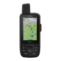
Using the map for navigation, measurement, and display customization.
Using the compass for direction and calibrating its accuracy.
Creating, saving, editing, and navigating to waypoints.
Creating, editing, and navigating saved routes.
Creating, editing, and navigating saved courses.
Recording activities, managing settings, and using TracBack.
Finding and navigating to destinations, and stopping navigation.
Manages messages, inReach weather, SOS, and MOB functions.
Navigating setup options and configuring system-wide settings.
Technical specifications and regulatory compliance information.
| Display Resolution | 240 x 400 pixels |
|---|---|
| Water Rating | IPX7 |
| Weight | 8.1 oz (230 g) |
| Memory | 16 GB |
| High-sensitivity Receiver | Yes |
| Waypoints/Favorites/Locations | 10, 000 |
| Routes | 250 |
| Ability to Add Maps | Yes |
| Automatic Routing | Yes |
| Map Segments | 15, 000 |
| Smart Notifications | Yes |
| LiveTrack | Yes |
| Display Size | 3 inches |
| Display Type | transflective color TFT |
| Battery Type | rechargeable lithium-ion |
| Wireless Connectivity | Wi-Fi, Bluetooth, ANT+ |
| Interface | USB |
| Track Log | 20, 000 points, 250 saved tracks |
| Birdseye Direct Imagery | Yes |
| Sensors | Barometric altimeter, compass |
| inReach Features | Location Sharing |
| Preloaded Maps | Yes (TopoActive) |