Do you have a question about the Garmin GPSMAP 9000 Series and is the answer not in the manual?
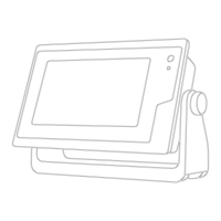
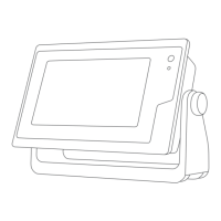
Identifies key components of the chartplotter device, including touchscreen, power key, and sensor.
Explains basic touch interactions like tapping, dragging, pinching, and spreading for device control.
Details the ports and connectors on specific GPSMAP models for various input/output connections.
Provides useful tips and shortcuts for operating MFD models, including power and brightness adjustments.
Step-by-step guide for inserting microSD cards into specific GPSMAP models for data storage.
Details on how the device acquires GPS signals for accurate positioning and troubleshooting.
Explains the home screen layout and access to chartplotter features, dependent on connected accessories.
How to set a PIN to prevent unauthorized access to the device for anti-theft protection.
Guide to creating custom combination pages by arranging multiple windows and data.
Explanation of presets and how they optimize screen settings for various activities like fishing or cruising.
How to use voice commands with a compatible headset for controlling chartplotter functions.
Lists common voice commands for controlling device functions, navigation, and media playback.
Information on pairing and using the GRID remote control for chartplotter operation.
Steps to connect a mobile device to the chartplotter using the ActiveCaptain app for data sync.
How to receive mobile device notifications like calls and texts directly on the chartplotter.
How to download and install software updates for the chartplotter using the ActiveCaptain app.
Steps to set up the chartplotter's own Wi-Fi network for connecting wireless devices.
How to connect wireless devices, like phones or tablets, to the chartplotter's Wi-Fi network.
Steps to pair a wireless remote control with the chartplotter for remote operation.
Details about compatibility with Garmin Navionics+ cartography and premium chart features.
How to set a destination and navigate using Go To, Route To, or Auto Guidance.
Overview of optional premium chart features like 3D views, satellite imagery, and aerial photos.
How Auto Guidance uses chart data to determine the best path, avoiding obstacles and hazards.
Steps to create and save custom routes with multiple turns for planned navigation.
Information on recording, saving, and viewing boat tracks for path history and analysis.
How to use the device to improve performance at the start of a sailing race.
How to operate and configure the sailboat autopilot system, including wind hold and tacking.
How to configure laylines for sailing races using wind sensor data for optimal course plotting.
Describes the full-screen traditional sonar view and its display of detected objects.
Details the Garmin ClearVü sonar view for detailed, picture-like imaging of structures below the boat.
Overview of Panoptix sonar views for real-time underwater imaging around the boat.
Overview of various sonar setup options for transducer settings and screen appearance.
How to read and interpret radar display information for effective use in various conditions.
How to overlay radar information onto navigation charts for enhanced visualization.
How to adjust radar gain manually or automatically for optimal performance and target detection.
How to set up guard zones to alert when anything enters a specified area around the vessel.
Information on installing and configuring the autopilot system correctly for boat operation.
Steps to engage the autopilot to take control of steering and maintain heading.
How to use preset steering patterns for fishing and other specialty maneuvers like U-turns.
Information on connecting and using the Reactor autopilot remote control for wireless operation.
How connecting a VHF radio enables DSC features like position transfer and distress calls.
How to navigate to the location of a vessel in distress using DSC position information.
How to initiate distress calls from the chartplotter, which are then sent via radio.
How to access and navigate through different gauge pages to view engine and environmental data.
Explains red icons indicating engine abnormalities and potential issues on the gauges page.
How to view Yamaha engine data and related settings via the engine network.
Steps to connect an inReach device to the chartplotter for message management.
How to reply to inReach messages using pre-written quick or custom text messages.
How to add and customize digital switching pages for controlling onboard circuits.
How to configure navigation light interlocks and wiring options for compliance.
How to control the Power-Pole anchor system using the chartplotter interface.
How to enable the Mercury Helm feature for controlling Mercury engines and overlays.
How to set and adjust cruise control functions for Mercury engines via the chartplotter.
How to view tide station data, including tide height and next high/low tide times.
How to view celestial information like sunrise, sunset, moonrise, moonset, and moon phases.
How to view system messages and alarms prioritized by severity in the Warning Manager.
Steps to open the media player and connect compatible audio devices like stereos.
How to manage speaker zones and create stereo groups for audio control.
What equipment and subscription are needed to use SiriusXM satellite weather and radio.
How weather warnings and bulletins are displayed on the chart with shaded areas.
How to select the source for video feeds from connected cameras or devices.
How to use advanced camera tracking features like Compass Lock and Vessel Lock.
How to adjust display settings, audio output, satellite positioning, and system information.
How to adjust units, language, navigation, filters, and keyboard layout preferences.
How to view connected devices and configure NMEA 0183 and NMEA 2000 network settings.
Detailed technical specifications for the GPSMAP 8x10 model, including dimensions and power.
Detailed technical specifications for the GPSMAP 8x12 model, including dimensions and power.
How ActiveCaptain and Garmin Express apps help manage Garmin chartplotters and devices.
Common troubleshooting steps for device issues like GPS signal loss or power problems.
| Touchscreen | Yes |
|---|---|
| Waterproof Rating | IPX7 |
| Chartplotting | Yes |
| Wireless Connectivity | Wi-Fi, Bluetooth |
| AIS Support | Yes |
| Sonar Support | Yes, supports Panoptix |
| Radar Compatibility | Yes |
| Digital Switching | Yes |
| Video Input | Yes |