Do you have a question about the Garmin Monterra and is the answer not in the manual?
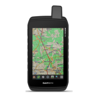
Identifies the physical buttons, ports, and features of the Monterra device.
Details battery types, warnings, and handling for optimal performance and safety.
Learn how to create, find, edit, and delete saved locations on your device.
Covers creating, editing, and viewing routes between multiple points for navigation.
Instructions on how to pause, resume, and customize track recording settings.
Guidance on navigating back to a starting point using recorded track logs.
Create and manage adventures to share journeys with tracks and photos.
General guidance on navigating to destinations using maps and compass features.
Steps to manually calibrate the electronic compass for accurate readings.
How to navigate to a distant object by locking its direction.
Understanding and using the elevation plot to view altitude changes over distance or time.
Guide to capturing photos, including panoramic shots, and recording videos.
Instructions for downloading, filtering, and navigating to geocaches.
How to set up alarms that trigger when you enter a specific radius.
Instructions for tuning into NOAA weather broadcasts and alerts.
Personalize your device by adding shortcuts and widgets to the home screen.
How to fix the screen orientation to portrait or landscape mode.
Customize data displayed on maps, compass, and other screens.
Configure how the device calculates routes based on activity type.
Manage altimeter settings, including auto-calibration and pressure trending.
Steps to connect your device to Wi-Fi networks for updates and data transfer.
Create and select profiles to optimize settings for different activities.
Adjust screen color mode, brightness, wallpaper, and backlight timeout.
Set up a pattern, password, or PIN to secure your device's lock screen.
Instructions on how to back up accounts, settings, and application data.
Details about battery types, life, and maximizing battery usage for longevity.
Guidelines for cleaning, protecting, and maintaining the device.
Information on the device's water resistance rating and post-immersion care.
Technical details including battery type, water resistance, and operating temperatures.
Instructions for connecting to a computer and updating the device software.
Steps to reset the device to factory defaults if it becomes unresponsive.
Resources for finding additional product information and support.
Information about using additional map products with the device.
Details on pairing and using the tempe wireless temperature sensor.
| Geocaching (GPS stash hunt) | Yes |
|---|---|
| Marine (chartplotters, sounders) | - |
| Routes quantity | 200 |
| Number of waypoints | 4000 |
| Number of points of interest | 10000 |
| Traffic Message Channel (TMC) | No |
| Map coverage | All Europe |
| Map view options | 2D/3D |
| Display diagonal | 4 \ |
| Display resolution | 272 x 480 pixels |
| Placement supported | Vertical |
| Storage media type | Flash |
| Compatible memory cards | MicroSD (TransFlash) |
| Internal storage capacity | 2 GB |
| Form factor | Handheld/Fixed |
| Product color | Black |
| International Protection (IP) code | IPX7 |
| Megapixel | 8 MP |
| USB 2.0 ports quantity | 1 |
| Power source type | Battery |
| Battery life (max) | 22 h |
| Cables included | USB |
| Depth | 36.3 mm |
|---|---|
| Width | 74.8 mm |
| Height | 149.6 mm |
| Weight | 331 g |
