Do you have a question about the Garmin Oregon 600 and is the answer not in the manual?
Tasks to set up the device and learn basic features.
Identifies physical buttons and ports on the device.
Details on battery types, warnings, and handling.
Record, find, edit, delete, and project locations.
Create, edit, view, and delete routes.
Record, customize, and manage track logs.
Search for destinations by name, address, or nearby location.
Steps to start navigation to a chosen location.
How to end an active navigation session.
Mark and navigate back to a Man Overboard location.
Create and manage adventures for sharing journeys.
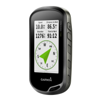
Use map and compass for directional guidance.
Recalibrate the device's compass for accuracy.
View, navigate to points, change type, and reset elevation data.
View and reset trip data.
Capture, view, sort, and manage photos.
View, sort, set as wallpaper, delete, or navigate to photos.
Transfer and filter geocache data.
Navigate to geocaches and log findings.
Activate search for chirp accessories.
Locate geocaches containing a chirp accessory.
Set up and use the device for fitness activities.
View and manage activity history.
Pair sensors and understand heart rate zones.
Manually adjust heart rate zones for fitness.
Navigate 3D views and share data wirelessly.
Set proximity alarms, alarms, and countdown timers.
Use built-in calculator and view calendar/almanacs.
Use stopwatch and view GPS satellite status.
Adjust backlight and customize main menu.
Create shortcuts and configure data fields.
Customize dashboards and manage user profiles.
Assign shortcuts and configure system options.
Configure satellite system, WAAS, and text language.
Set serial interface and AA battery type.
Adjust display timeout, orientation, and appearance.
Enable maps, set orientation, and guidance text.
Adjust map detail, relief, vehicle icon, and zoom.
Adjust map drawing speed and text size.
Configure recording method, interval, archive, and format.
Select activity and manage route transitions.
Set compass display and north reference.
Use navigation pointers and manage compass switching.
Set auto calibration, barometer mode, and plot type.
Display and set style for geocache data.
Program and search for chirp accessories.
Create filters and edit found geocache count.
Set auto laps and configure user profile.
Set heart rate zones and activity type.
Select chart mode and set marine alarms.
Reset trip data, specific settings, or all defaults.
Update software and reset the device.
View device info and register the device.
Attach/remove clip, use optional maps.
Use the tempe temperature sensor.
Accuracy, bearing, distance, ETA, elevation data.
Ascent/Descent, cadence, heart rate, lap, speed.
Barometer, battery, temperature, time.
Off course, pointer, time to dest, speed data.
| Outdoor (hiking, trekking) | Yes |
|---|---|
| Marine (chartplotters, sounders) | No |
| Routes quantity | 200 |
| Number of waypoints | 4000 |
| Navigation protocols | NMEA 0183 |
| Form factor | Handheld |
| Product color | Black, Grey, Orange |
| Display diagonal | 3 \ |
| Display resolution | 240 x 400 pixels |
| Display size (HxV) (imperial) | 2.5 x 1.5 \ |
| Storage media type | - |
| Compatible memory cards | MicroSD (TransFlash) |
| Internal storage capacity | 1.5 GB |
| USB 2.0 ports quantity | 1 |
| Supported radio bands | Not supported |
| Battery type | AA |
| Power source type | Battery |
| Battery life (max) | 16 h |
| Battery technology | Lithium |
| Number of batteries supported | 2 |
| Depth | 33 mm |
|---|---|
| Width | 61 mm |
| Height | 114 mm |
| Weight | 209.8 g |