Do you have a question about the Garmin Personal Navigator GPS 48 and is the answer not in the manual?
Information about satellite constellation and health transmitted by GPS satellites.
The compass direction from your position to a destination.
The bearing from the starting point to your present position.
Indicates the amount of off-course deviation on the highway page.
North is 000°, east 090°, south 180°, west 270°, with diagram.
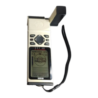
Explains the function of each key, including GOTO, MARK, PAGE, QUIT, ENTER.
Describes two methods for initial GPS setup: country selection or auto-location.
Shows satellite positions and signal strength for reception monitoring.
Displays current location, heading, speed, and position coordinates.
Steps to press the MARK key and save the current GPS fix as a waypoint.
Steps to select a GOTO destination and navigate back to a saved waypoint.
Procedure to stop navigating to a selected waypoint by cancelling the GOTO function.
How to modify the screen contrast level using the Satellite Page.
Interpreting satellite visibility, signal quality, and position fix status.
Describes states like Searching, Acquiring, 2D Nav, 3D Nav, Poor Cvg, Not Usable.
Steps to erase all stored data, including routes, waypoints, and track logs.
Options for displaying trip odometer, trip timer, elapsed time, and speed.
How to control map view, zoom levels, and configure display items.
Lists and describes the 10 symbols representing different types of nautical navaids.
Steps to activate the pan function and move the map using arrow keys.
Select map orientation (North Up, Track Up, DTK Up) and display items.
Determines how often positions are stored in the track log (Auto, Time Interval).
Lets you search the internal database for a city by spelling its name.
Explains the graphic highway, CDI scale, and how to stay on course.
Compares the Compass Page (directional pointer) and Highway Page (graphic highway).
Shows the nine nearest user waypoints with bearing and distance.
Procedures to review or delete a configured proximity waypoint.
Steps to manually input coordinates to create a new waypoint.
How to choose from 16 symbols for waypoint recognition on the map.
Feature to automatically display matching waypoints as you type a name.
Marks and sets a course to a position for quick response to passing positions.
Options for recording tracks: Off, Fill, or Wrap.
Explains "legs" and "active to/from" waypoints in route navigation.
Explains options like Copy, Clear, Invert, and Activate for managing routes.
Options to review, insert, delete, or change waypoints within an active route.
Calculates distance, bearing, sunrise, and sunset times between points.
Allows selection of various latitude/longitude formats (degrees, UTM, etc.).
Selects the +/- range of the CDI bar scale on the Highway Page.
Specifies formats for connecting external devices and data transfer options.
How to enable or disable alarms and set their activation distance.
Steps to engage simulator mode from the System Setup menu.
Case, size, weight, and temperature range details.
Receiver type, acquisition time, update rate, and accuracy.
Detailed procedure for opening the compartment, inserting batteries, and securing the door.
Explains various alert messages like 'Accuracy Degraded' and 'Route is Full'.
Defines abbreviations for light characteristics like Fixed, Flashing, and Occulating.
| Display Type | LCD |
|---|---|
| Display | Monochrome |
| Water Resistance | IPX7 |
| Waypoints/Favorites/Locations | 500 |
| Battery Type | 4 AA batteries (not included) |
| Channels | 12 |
| Weight | 255 grams |
| Map Data | No built-in maps |
| Routes | 20 |
| Track Log | 1024 points |
| Interface | RS-232 |