A28-1146-102-00
Federal Aviation Administration (FAA) Advisory Circulars
A-8
LIGHTNING
A lightning strike can puncture the skin of an aircraft and can damage
communication and electronic navigational equipment. Lightning has
been suspected of igniting fuel vapors causing explosion; however,
serious accidents due to lightning strikes are extremely rare. Nearby
lightning can blind the pilot rendering him momentarily unable to
navigate by instrument or by visual reference. Nearby lightning can
also induce permanent errors in the magnetic compass. Lightning
discharges, even distant ones, can disrupt radio communications on
lowandmediumfrequencies. Thoughlightningintensityandfrequency
have no simple relationship toother storm parameters, severe storms,
as a rule, have a high frequency of lightning.
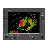
WEATHER RADAR
Weather radar detects droplets of precipitation size. Strength of the
radar return (echo) depends on drop size andnumber. The greaterthe
number of drops, the stronger is the echo,and the larger the drops, the
stronger is the echo. Drop size determines echo intensity to a much
greater extent than does drop number. Hailstones usually are covered
withafilmofwaterand, therefore,act ashuge waterdroplets givingthe
strongest of all echoes.
Numerous methods have been used in an attempt to categorize the
intensity of a thunderstorm. To standardize thunderstorm language
betweenweatherradaroperatorsandpilots,theuseofVideoIntegrator
Processor (VIP) levels is being promoted.
The National Weather Service (NWS) radar observer is able to
objectivelydeterminestormintensitylevelswithVIPequipment. These
radar echo intensity levels are on a scaleof one tosix. If the maximum
VIP levels are 1 ”weak” and 2 ”moderate,” then light to moderate
turbulence is possible with lightning. VIP Level 3 is strong and severe
turbulence is possible with lightning. VIP Level 4 is very strong and
severe turbulence is likely with lightning. VIP Level 5 is intense with
severe turbulence, lightning, hail likely, and organized surface wind
gusts. VIP Level 6 is extreme with severe turbulence, lightning, large
hail, extensive wind gusts, and turbulence.
Thunderstorms build and dissipate rapidly. Therefore, do not attempt to
plan a course betweenechoes. Thebest use ofgroundradarinformation
is to isolate general areas and coverage of echoes. You must avoid
individualstormsfrom in-flight observationseitherby visual sighting or by
airborne radar. It is better to avoid the whole thunderstorm area than to
detour around individual storms unless they are scattered.
 Loading...