Do you have a question about the Honeywell IntuVue RDR-4000 and is the answer not in the manual?
Details key operational enhancements of the RDR-4000 radar system.
Outlines critical limitations and considerations for using the radar system.
Explains how to turn the RDR-4000 radar system on and off.
Describes the procedure for testing the RDR-4000 radar system.
Illustrates various test patterns displayed by the RDR-4000 radar.
Provides simplified operating procedures for takeoff and departure.
Details simplified operating procedures for climbing to FL200.
Outlines simplified operating procedures for cruising above FL200.
Covers simplified operating procedures for descent and approach.
Guides on how to perform avoidance maneuvers using the radar.
Provides detailed instructions for system power-up and testing.
Explains how to select and configure radar systems for operation.
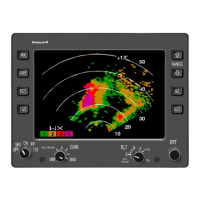
Details how the RDR-4000 detects and displays weather information.
Describes the system's capability to detect and display turbulence.
Covers the display of hail and lightning prediction icons.
Explains the REACT feature for attenuating weather detection.
Details the Predictive Windshear (PWS) detection system.
Describes methods for analyzing weather using manual mode.
Explains the use of Ground Map mode for terrain identification.
Details how to use and adjust the radar gain control.
Describes how to suppress hazard icons and turbulence indications.
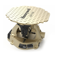
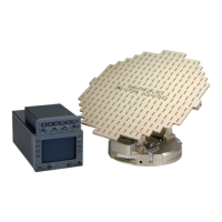
Provides descriptions of the RDR-4000 system's main components.
Explains fundamental principles of airborne weather radar operation.
Describes characteristics of storm cells relevant to radar interpretation.
Guides on planning flight paths to avoid weather hazards.
Explains azimuth resolution as a function of antenna beam width.
Discusses how beam width impacts vertical resolution of weather.
Explains how heavy rain or terrain can create shadowed areas on display.
Details how RF interference affects radar display and interpretation.
Explains how the radar system detects windshear.
Describes microbursts and their characteristics.
Details the process by which the radar detects windshear.
Provides guidance on flying to survive microburst encounters.
Explains the 3D volumetric scanning and data processing.
Details how the system extracts ground clutter using a topography database.
Differentiates between Flight Path Weather and Secondary Weather.
Defines the boundaries of the flight path weather envelope.
Explains the Constant Altitude mode for weather analysis.
Provides essential safety warnings, especially regarding radiation.
Details the Maximum Permissible Exposure Level (MPEL) for radiation.