Do you have a question about the Humminbird 858c and is the answer not in the manual?
Explains sonar technology, sound waves, and signal interpretation.
Describes Side Imaging sonar for wide area surveys and detailed bottom topography.
Explains the 200/83 kHz DualBeam PLUS sonar system with 60° coverage.
Details the optional QuadraBeam PLUS transducer with 90° coverage and fan-shaped beams.
Describes the integrated Minnkota trolling motor transducer with temperature sensing.
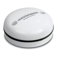
Explains GPS positioning, satellite triangulation, and functionality.
Discusses how configurations affect installation and menu options.
Explains using the Accessory Bus to expand system functionality with accessories.
Lists basic installation tasks: control head, transducer, GPS receiver, and testing.
Discusses choices for mounting the control head: Gimbal or In-dash.
Details installing the DualBeam PLUS transducer on a transom.
Guides installing the DualBeam PLUS transducer inside the hull.
Covers installing the Side Imaging transducer on a transom.
Provides instructions for mounting transducers on trolling motors.
Explains how to mount the GPS receiver on an existing antenna stem.
Details deck mounting the GPS receiver when cable can route underneath.
Guides deck mounting the GPS receiver when cable must route to the side.
Describes the purpose and operation of various keys on the control head.
Explains different display modes and how to customize them.
Covers displaying two views simultaneously on the screen.
Details how to navigate and interact with the chart display.
Explains marking waypoints, creating routes, and saving tracks.
Describes the organization and use of the system's menus.
Explains the initial modes: Normal, Simulator, and System Status.
Provides shortcuts to frequently used settings, tailored to the current view.
Offers access to standard menu settings organized by tabs.
Sets which sonar returns from the transducer are displayed on the screen.
Selects the frequency for Side Imaging® and Down Imaging™ beams.
Adjusts the filter to remove surface clutter noise.
Controls how sonar returns are displayed, offering Max or Clear modes.
Uses signal processing to interpret sonar returns and display fish symbols.
Adjusts the threshold for Fish ID+™ detection algorithms.
Sets the RTS Window to Wide or Narrow, or turns it off.
Selects the color palette for the display.
Selects the method to represent bottom and structure on the display.
Adjusts the width of the zoomed view in Sonar Zoom View.
Changes the sensitivity of the 83 kHz sonar beam.
Adjusts the sensitivity of the 455 kHz beam.
Divides the display into sections separated by horizontal depth lines.
Adjusts the sonar filter to limit interference from various sources.
Controls the maximum depth of operation for the unit.
Configures the unit for operation in fresh or salt water for accuracy.
Allows selection of the transducer type connected to the system.
Allows display or suppression of the color bar in Sonar View.
Allows display or suppression of a water temperature graph.
Controls the beam width for Down Imaging™ views.
Allows viewing and managing the current track data.
Allows viewing and managing saved track data.
Manages saved locations (waypoints) for navigation and interest points.
Allows creation, editing, and travel of navigation paths between waypoints.
Selects whether the chart view is drawn North-Up or Course-Up.
Allows selection of True North or Magnetic North for bearings.
Sets the feature to automatically declutter waypoint names and icons.
Sets the orientation of the trolling grid for fishing.
Selects the time period between trackpoints to define the track's path.
Sets a minimum distance of travel before a trackpoint is added.
Sets the depth range for color shading on tracks.
Changes the map coordinate system to match paper maps.
Displays or hides an arrow projecting the boat's current course.
Displays or hides an outline on charts showing the Bird's Eye view.
Exports saved tracks, waypoints, and routes to an MMC/SD card.
Deletes all saved tracks, waypoints, and routes.
Allows continuous navigation around a waypoint, even if passed multiple times.
Selects which GPS receiver to use if multiple are connected.
Allows displaying or hiding a grid showing latitude and longitude lines.
Allows displaying or hiding navigational aids in Bird's Eye View.
Selects which chart to use from built-in charts or a map card.
Sets the boat's position for use in the Simulator mode.
Changes the map offset used by the Fishfinder for correction.
Clears any applied Map Offset.
Changes the depth used for shading on Chart Views.
Selects how much chart detail is displayed on Navigation Views.
Allows displaying or hiding map borders indicating different map areas.
Displays or hides spot soundings (depth measurements) on the chart.
Selects a built-in chart for NVB units, or uses Auto-select.
Sets whether water contour lines are visible or hidden in Chart Views.
Sets depth shading in Chart Views to Off or Shaded.
Highlights a specific depth setting in chart views.
Adjusts the range on each side of the highlighted depth.
Changes the water level being read from the control head.
Selects a minimum shallow depth to highlight in red in Chart Views.
Allows viewing the list of lakes included on the installed MMC/SD card.
Selects the units of measure for all depth-related readouts.
Selects the units of measure for all temperature-related readouts.
Selects the units of measure for all distance-related readouts.
Selects the units of measure for speed-related readouts.
Sets the menu system to Normal or Advanced for simplicity or control.
Selects the display language for menus (International only).
Resets the Triplog providing timer, distance, and average speed.
Resets all menu settings to their factory defaults.
Sets the information displayed in the fixed position data windows.
Adjusts the digital depth readout to indicate depth from waterline or keel.
Adjusts the auxiliary temperature readout by the entered amount.
Adjusts the temperature readout by the entered amount.
Adjusts the speed readout by a percentage based on paddlewheel movement.
Selects the time zone reference for GPS receiver time reporting.
Adjusts the time display to account for local Daylight Saving Time.
Selects the format for latitude and longitude position display.
Selects the time format (12 or 24 hour) for display.
Selects the date format for display.
Adds a tenth decimal place to readouts like temperature and depth.
Turns NMEA output on or off for connecting to other NMEA devices.
Deactivates Sonar and removes Sonar Views from view rotation.
Controls whether Demonstration Mode is visible or off.
Sets when the control head will beep or sound for key presses and alarms.
Sets the video format sent to a remote monitor.
Shows available accessories and related menu options.
Activates saving screen snapshots to an MMC/SD card.
Allows locating and monitoring other vessels using AIS technology.
Provides steps to resolve issues where the system does not power up.
Guides troubleshooting when the system defaults to Simulator mode.
Addresses common issues affecting display quality and provides solutions.
Identifies sources of electrical noise or interference affecting the display.
Details the QuadraBeam PLUS transducer and its functions.
Describes the accessory for obtaining barometric pressure and trend data.
Explains connecting handheld or NMEA GPS devices.
Describes receiving remote sonar signals via a SmartCast® sensor.
Details connecting to a PC for software updates and features.
Describes the integrated transducer for Minnkota trolling motors.
Mentions the CannonLink™ Downrigger Controller and its features.
Provides definitions for sonar-related technical terms.
Defines terms related to GPS positioning and navigation.
Provides a template for installing the Side Imaging transducer.
| Display Type | Color TFT |
|---|---|
| GPS | Yes |
| Chartplotting | Yes |
| Sonar Standard | DualBeam PLUS |
| Target Separation | 2.5 Inches |
| Power Output RMS | 500 Watts |
| Power Output Peak to Peak | 4000 Watts |
| Backlight | Yes |
| Humminbird Basemap | Yes |
| Navionics Compatible | Yes |
| Power Input | 10-20 VDC |
| Waypoints | 3000 |
| Routes | 50 |
| Waterproof Rating | IPX7 |
| Sonar Coverage | 20° and 60° |
| Mount Type | Gimbal bracket |