KongsbergEMSeries
GGADatagram
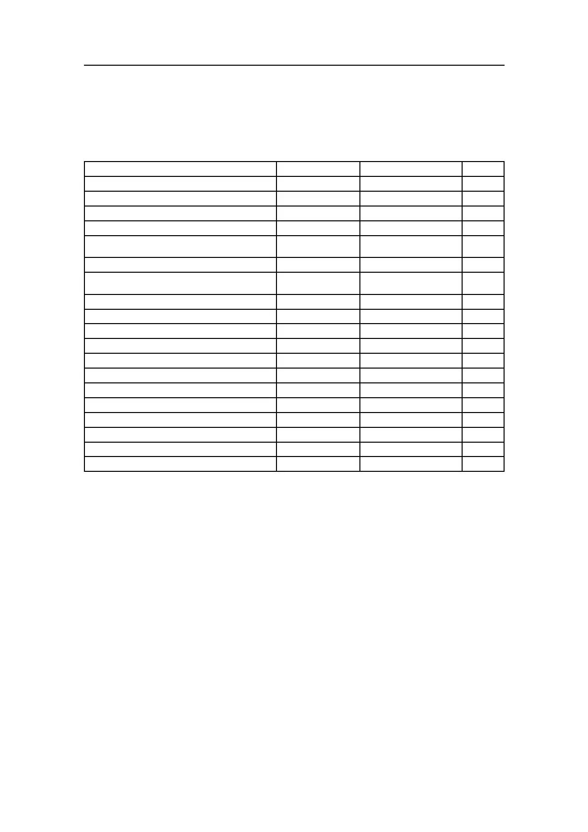
Table1GGADatagram
DataDescriptionFormatValidrangeNote
Startidentier=$
Always24h
——
Talkeridentier
aa
Capitalletters
—
SentenceformatterAlwaysGGA,
——
UTCofposition
hhmmss.ss,000000to235959.9...
—
Latitudeindegreesandminutes,plusoptional
decimalminutes
llll.ll,0000to9000.0...
—
Latitude–N/S
a,
NorS
—
Longitudeindegreesandminutes,plusoptional
decimalminutes
yyyyy.yy,
00000to18000.0...
—
Longitude–E/W
a,
EorW
—
GPSqualityindicator
x,
0to81
Numberofsatellitesinuse
xx,
00to12
—
HDOP
x.x,—
1
Antennaaltituderemeansealevel(geoid)
x.x,—
2
Unitsofantennaaltitude
M,
——
Geoidalseparation(sealevelreWGS-84)
x.x,—
2
Unitsofgeoidalseparation
M,
——
AgeofdifferentialGPSdata
x.x,——
Differentialreferencestationid
xxxx,
0000to1023
—
Checksum*hh
——
Endofsentencedelimiter=CRLF
Always0Dh0Ah
——
Notes
1TheHDOP(HorizontalDilutionOfPrecision)valuewillbescaledandcopiedtothe
”Measureofpositionxquality”eldinthepositionoutputdatagram.Thescale
factordependsupontheGPSqualityindicator’svalue:
•1-(SPSorstandardGPS)=>1000
•2-(differentialGPS)=>100
•3-(PPSorpreciseGPS)=>200,but10ifGGAistreatedasRTK.(SeeNote2)
•4-(kinematicGPSwithxedintegers)=>10
•5-(kinematicGPSwithoatingintegers)=>50
•6-(estimatedordeadreckoningmode)=>1000
•7-(manualinputmode)=>1000
•8-(testmode)=>1000,but10ifGGAistreatedasRTK.(SeeNote2)
•The”Measureofpositionxquality”eldwillbesetto65534(largestvalid
number)iftheindicatoriszero(non-validposition).
Thisscalingisusedtogiveatleastarelativelycorrectpositionxqualitychange
(intheorderofcm)iftherearedropoutsindifferential,preciseorkinematic
measurements,althoughHDOPisnotametricvalue.
12
850-160692/S