Do you have a question about the Magellan NAV 6500 and is the answer not in the manual?
Emphasizes using good judgment, care, and caution for safe navigation.
Advises using only Magellan cables and antennas to ensure performance and warranty.
Outlines the terms for using the included software for personal use.
Lists the items included in the receiver package.
Explains manual conventions and commonly used terms for clarity.
Provides an overview of the receiver's features and capabilities.
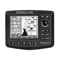
Details the functions of the receiver's buttons and controls.
Instructions for turning the unit on/off and adjusting contrast/backlighting.
Guides on setting initial position, time, and date for accurate fixes.
Explains basic navigation principles using waypoints and routes.
Covers basic operations like power, cancelling, inputting data, and contrast.
Details the different navigation screens (SAT, MAP, NAV1, NAV2) and their functions.
Covers creating, saving, editing, viewing, finding, and deleting waypoints.
Instructions for creating, activating, editing, and managing routes.
Allows setting time, date, contrast, beeper, and language preferences.
Configure coordinate system, map datum, north reference, and map orientation.
Control the display of land, marine, and nav-aid features on the map.
Configure NMEA output, input, and baud rates for external devices.
Options for resetting total memory or GPS data to default settings.
Tool for correcting position bias between electronic and paper charts.
Troubleshooting steps for when the receiver will not turn on.
Guidance for resolving problems with computing a position fix.
Solutions for a frozen display or unresponsive keypad.
Explanation of system warnings and alarm messages.
Guides for mounting, antenna, and electrical connections.
Reference for map symbols representing navigation aids and features.
Information on inserting, removing, and using C-MAP data cartridges.
Details on NMEA data output formats for external devices.
Technical details including size, weight, operating characteristics, and power.
Explanation of LAT/LON, UTM, and other coordinate systems used.
Overview of the Global Positioning System and how it works.
Alphabetical listing of terms and their definitions used in the manual.
| Preloaded Maps | Yes |
|---|---|
| Battery | Rechargeable Lithium-ion |
| Voice Guidance | Yes |
| Lane Assist | Yes |
| Speed Limit Warning | Yes |
| Accepts Data Cards | Yes |
| Display | Color |
| Traffic Updates | Yes |
| Processor | Unknown |
| Memory | Unknown |