Do you have a question about the MLR FX312 and is the answer not in the manual?
Displays geographical position, satellite status, and differential mode indicator.
Shows speed over ground (SOG) and course over ground (COG).
Functions for navigating to and managing waypoints.
Initiates the function to navigate to a selected waypoint.
Stops the navigation to the currently active waypoint.
Allows choosing between DATA, COMPASS, 3D ROAD, or RADAR views.
Selects a different waypoint as the new destination.
Allows manual entry of a new waypoint's name, icon, and coordinates.
Creates a waypoint using its distance and bearing from a known point.
Configures a waypoint to remain active after the GPS is switched off.
Edits the details of an existing waypoint.
Removes selected waypoints or clears all stored waypoints.
Shows the distance and bearing between two selected waypoints.
Displays the amount of used and available memory for waypoints.
Guides the user along a pre-defined sequence of waypoints.
Starts the navigation along a selected route.
Stops the navigation along the active route.
Selects the visual display format for route navigation.
Selects a different route to follow.
Allows manual creation of a new route by linking waypoints.
Edits an existing route by adding, deleting, or reordering waypoints.
Removes selected routes or clears all stored routes.
Manually moves to the next waypoint in an active route.
Shows range and bearing between each waypoint in a route.
Displays the amount of used and available memory for routes.
Visualizes track, waypoints, and chart outlines on a graphical display.
Stops tracking and sets the current position as a return point.
Chooses between a full-screen or split-window display on the plotter.
Selects how waypoint names are shown (icon only, icon+letter, icon+name).
Configures data displayed in plotter zones (e.g., range, speed, date).
Shows the outline of a loaded or created chart.
Allows creating or loading chart outlines from paper charts or PC.
Erases stored track data or chart outline data.
Copies track data to chart outline memory and vice versa.
Sets the distance interval for recording track points.
Displays used and free memory for track and chart outline data.
Adjusts the zoom level for the plotter display.
Enables moving the plotter view to examine specific points.
Repositions the plotter view to center on a selected waypoint.
Functions for emergency position recording and marking points of interest.
Records the current position instantly for emergency return.
Stores event waypoints or points of passage with a name, icon, and comment.
Allows simulation of GPS navigation functions for training.
Displays satellite constellation and signal strength.
Guides on using the device with DGPS receivers for enhanced accuracy.
Connects and configures the FX312 with the MLR DF300 for DGPS.
Connects the FX312 to third-party DGPS receivers.
Operates the FX412's integrated DGPS receiver.
Explains using Digipoint for entering waypoints, routes, and chart outlines.
Interprets messages received from differential correction stations.
Displays software/boot versions and allows updating the GPS year.
Instructions for switching the GPS unit on and off.
Details on viewing received satellites and signal strengths.
Controls display brightness and contrast for optimal viewing.
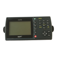
Explains the function of each key on the GPS unit.
Describes cursor movement and selection actions within menus.
Defines acronyms and icons used in the GPS interface.
Defines units of measurement like knots, miles, meters, etc.
Accesses core settings like coordinates, map datums, and language.
Selects the desired format for displaying geographical positions.
Selects the map datum used on paper charts for accurate alignment.
Sets the geographical region for optimized GPS performance.
Adjusts the time offset between UTC and local time.
Selects the display language for the GPS interface.
Configures what altitude and accuracy information is shown.
Assigns functions (Mark or MOB) to the Mark/Mob key.
Enables or disables audible feedback for key presses.
Configures serial data communication formats for external devices.
Provides a summary of all user-configured settings.
Accesses settings for navigation units, filters, alarms, and logs.
Sets units for distance (NM, KM) and speed (KT, MPH, KMH).
Selects the unit for altitude display (Feet, Meters).
Selects the unit for displaying Cross Track Error (NM, KM, MPH).
Selects between 2D, 3D, or Auto positioning modes.
Adjusts filtering for smoother speed readings.
Enters magnetic variation for accurate compass readings.
Clears stored trip data (Log 1 and Log 2).
Configures arrival, anchor, and XTE alarms.
Alerts the user upon reaching a destination waypoint or completing a route leg.
Warns of vessel drift relative to a reference waypoint.
Warns of drift from the direct route to a reference waypoint.
Displays a summary of all configured navigation settings.
Lists all items included in the FX312 package.
Lists all items included in the FX412 package.
Lists main functions, data formats, and general features of both models.
Details specific DGPS functionalities and performance for the FX412.
Instructions for mounting the receiver unit.
Recommendations for optimal placement of the GPS antenna.
Specific guidance for installing the FX312 antenna.
Specific guidance for installing the FX412 antenna.
Checks the quality of the differential GPS signal reception.
Identifies potential sources of interference on board the vessel.
Determines if interference is conducted or radiated.
Provides methods to eliminate interference originating from the power supply.
Offers solutions to resolve interference caused by radiated signals.
Addresses interference caused by mechanical sources like propeller shafts.