Do you have a question about the Navman 8084 and is the answer not in the manual?
Explains the meaning of safety alert symbols like DANGER, WARNING, and CAUTION.
Covers critical safety warnings for installation, operation, GPS, charts, AIS, sonar, fuel, and simulation.
Provides a quick reference to the manual's built-in and optional features and their locations.
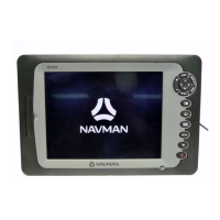
Describes the NAVMAN 8120/8084 as a rugged marine chartplotter and fishfinder.
Details procedures for cleaning the instrument screen and maintaining the transducer.
Explains the use of C-MAP chart cards and user cards for storing navigation data.
Provides instructions on how to safely remove and reattach the display unit from its mounting bracket.
Details the function of each button on the NAVMAN 8120 control panel.
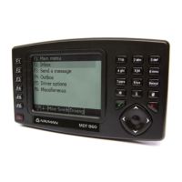
Details the function of each button on the NAVMAN 8084 control panel.
Explains key press actions, menu navigation, and data input methods like tick boxes and sliders.
Details how to turn the instrument on and off, including manual operation and auto power settings.
Covers adjusting display brightness and activating night mode for better visibility.
Explains how to activate the Man Overboard function to navigate back to a saved position.
Explains how the instrument indicates alarms and mentions user-settable alarm options.
Describes simulate modes for practicing operations without being on the water.
Introduces the main display windows and how to switch between them using favorite settings.
Details managing multiple display windows, including adding, deleting, and exchanging them.
Covers creating, selecting, and managing favorite display configurations for quick access.
Explains how to configure and display data headers on the instrument's windows.
Describes the compass display, showing boat course and bearing to destination.
Introduces the two primary navigation methods: direct to point and following a route.
Explains how the instrument shows navigation data when heading towards a specific point.
Details navigating to a waypoint from the chart window or the waypoint list.
Describes how to navigate to a specific point identified by the cursor on the chart.
Covers preparing, creating, and following routes, including starting and cancelling them.
Details the components of a typical chart window, including data header, compass, and boat position.
Explains the two chart modes: 'Center on boat' and 'Cursor' for positioning and interaction.
Describes how latitude and longitude coordinates are displayed in the data header.
Details how to adjust the chart scale using zoom functions for more or less detail.
Explains how to view stored information about chart symbols like waypoints and beacons.
Details methods for finding chart symbols by type (waypoints, ports) or by name.
Describes how to enable or disable the perspective view for the chart display.
Explains how to overlay radar data onto the chart screen for enhanced situational awareness.
Explains how to measure distances and bearings, and save courses as routes.
Explains the display of the projected boat position based on current speed and course.
Details how the instrument records and displays boat tracks over time.
Describes the video window function, showing camera input, and how to adjust picture settings.
Details the highway window, providing a bird's eye view of the course to a destination.
Defines waypoints and their attributes: name, icon, color, type, and display options.
Explains the waypoints window, listing all entered waypoints with their details.
Introduces the functions for managing waypoints, including creation and editing.
Details how to create new waypoints from either the chart or the waypoints list.
Covers the process of moving existing waypoints on the chart or by editing coordinates.
Explains how to edit waypoint data from the chart window or the waypoints list.
Details how to change waypoint data after it has been created.
Describes how to display a selected waypoint at the center of the chart window.
Covers deleting individual waypoints from the chart or the waypoint list.
Explains the process to delete all waypoints from the instrument's memory.
Explains how to modify individual data fields of a waypoint.
Describes how to sort the waypoint list by name, icon, or distance.
Refers to the section detailing navigation to a specific waypoint.
Explains the routes window, listing all entered routes with their details.
Introduces functions for managing routes, including creation and editing.
Details how to create a new route from the chart window or the routes list.
Lists menu options available during route creation, such as adding or inserting waypoints.
Details the process of creating a new route directly from the routes window interface.
Covers editing existing routes, either from the chart or the route list.
Describes how to view a selected route displayed on the chart window.
Details how to delete individual routes from the instrument.
Explains the process to delete all routes from the instrument's memory.
Refers to the section detailing how to navigate along a created route.
Explains GPS navigation principles, including WAAS/EGNOS and DGPS systems.
Details the satellite window, showing GPS status, time, date, and satellite signal strengths.
Introduces sonar functions, requiring an optional transducer for depth and fish finding.
Explains how the instrument uses a sonar transducer to send pulses and receive echoes.
Explains how sonar windows display history, echo appearance, and the effect of depth and scroll speed.
Explains how sonar shadows are created around areas the ultrasonic beam cannot see.
Explains the use of 200 kHz and 50 kHz frequencies for fishfinding.
Covers finding fish, using fish symbols, and interpreting fish arches on the sonar display.
Details the sonar range setting, including Auto and Manual modes for depth display.
Explains how gain and threshold settings control sonar detail and how to adjust them.
Describes the basic sonar history window, showing echoes from right to left.
Explains how to use extended history mode to review past sonar echoes.
Details sonar zoom displays and the 'Bottom lock' feature for focused viewing.
Describes the sonar bottom window, used for comparing bottom signal strengths.
Details the 50/200 kHz sonar window, showing history for both frequencies simultaneously.
Explains the A-Scope window, useful for manually adjusting gain and threshold settings.
Describes the gauges window, showing boat data as analog gauges and how to select layouts.
Describes the data window, displaying numeric data fields and graphs.
Explains how the fuel computer uses flow sensors to estimate fuel remaining, used, and economy.
Details the fuel display, showing speed, RPM, fuel flow, and remaining fuel levels.
Explains the meaning of 'Remaining', 'Used', 'Fuel Flow', 'Range', 'Economy', and 'Fuel Consumption Curve'.
Details procedures for updating the instrument when fuel is added or removed from the tank.
Explains how to set and manage low fuel alarms for the fuel tanks.
Covers selecting boat speed sensors (GPS or paddlewheel) for accurate calculations.
Explains the difference between water and ground speed and their effect on calculations.
Explains fuel consumption curves, showing fuel usage vs. engine RPM, and how to create them.
Details managing fuel consumption curves, including renaming and deleting them.
Explains how to use created curves to compare current boat performance.
Details the process for calibrating petrol/gasoline fuel flow sensors for accurate readings.
Describes the tides window, showing tide information and how to select dates.
Explains the user card window for storing and loading navigation data like waypoints and routes.
Details formatting the user card and sorting the displayed file names.
Explains how to view and interpret AIS vessel information displayed on the chart.
Explains how the instrument calculates TCPA and CPA to identify dangerous vessels.
Describes the AIS windows for viewing vessel lists and safety messages received.
Covers displaying full AIS details for vessels and sorting the vessel list by category.
Provides an overview of the DSC, Poll, and Buddy Track windows and their functions.
Details using the windows to display boats, navigate to them, and manage waypoints.
Details the radar window, explaining its components like range rings and North line.
Explains the available radar modes: Disabled, Warming, Standby, and Transmitting.
Details the steps to enable the radar system and its warm-up process.
Explains how to quickly switch between standby and transmit modes for the radar.
Details the procedure for disabling the radar functionality and its confirmation.
Discusses common issues affecting radar quality, such as clutter and noise.
Explains how to change the radar gain mode between Manual, Auto, and Range Rider.
Details how to adjust the radar gain level to optimize signal reception.
Explains how to change the sea clutter mode to suit different environments.
Explains how to adjust the sea clutter level to reduce unwanted signals.
Details how to adjust rain clutter settings to minimize interference from rain.
Explains how to set the threshold level for the weakest echo displayed on the radar.
Explains the echo expansion option to improve visibility of small targets.
Explains how to turn target trails on or off to track target movement.
Explains using Variable Range Markers/Electronic Bearing Lines to measure target range and bearing.
Details how to find range and bearing using a fixed VRM/EBL setup.
Details how to find range and bearing using a floating VRM/EBL for measuring between two points.
Explains how to move the PPI centre for optimal viewing in relative motion mode.
Details how to turn radar guard zones on or off for specific areas.
Explains how to enable or disable the visual display of radar guard zones on the screen.
Details how to change alarm settings for radar guard zones, including enter, exit, or both.
Explains how to adjust the boundaries and shape of radar guard zones.
Details how to set alarm sensitivity for radar guard zones based on target size.
Covers system settings including language, backlight, night mode, beep volume, and auto power.
Details chart setup options, including rotation, palette, map datum, and NMEA offsets.
Covers selecting color palettes and setting the map datum to match paper charts.
Explains applying NMEA datum offsets and map shifts for coordinate accuracy.
Details options within chart general, water, and land submenus for display customization.
Details how to apply a map shift for chart correction and how to clear it.
Covers sonar setup options like frequency, scroll speed, fish symbols, and palette.
Details radar setup options including rotation, motion mode, interference filter, and palette.
Covers radar installation settings like park position, zero bearing, zero range, and antenna height.
Details GPS setup options including source, DGPS source, restart GPS, static navigation, and filters.
Covers fuel setup options like source, number of engines/tanks, and engine/tank settings.
Details track setup options for recording, displaying, plotting interval, and memory usage.
Covers AIS setup options like filtering by type, distance, speed, and dangerous vessels.
Details log setup options for resetting trip distance, total distance, and engine hours.
Explains how to set up and configure various alarms, including trigger values and beeper settings.
Covers setting units for distance, speed, depth, fuel, compass, temperature, and pressure.
Details communication setup options, including NMEA out, NMEA data, and Lat/Lon decimal places.
Explains how to calibrate speed, speed filter, and temperature readings for accuracy.
Covers time setup options, including local offset, time format, and date format.
Refers to the section detailing how to set up and manage favorite displays.
Explains simulate mode options for Normal and Demo simulations, including speed and route settings.
Provides general warnings and cautions for installing the unit, emphasizing safety and proper mounting.
Lists all the components and accessories included in the 8120/8084 package.
Lists optional sensors and instruments that can be connected to the unit for expanded functionality.
Provides guidance on selecting a suitable mounting position for the display unit, considering visibility and environment.
Details the steps for flush mounting the 8120/8084 unit into a console.
Details the steps for mounting the 8120/8084 unit using the provided bracket.
Explains wiring the power/data cable for basic power and auto power modes.
Covers selecting and installing GPS antennas, including DGPS sources and restarting GPS.
Details connecting the sonar transducer and setting up sonar options.
Covers installing NAVMAN petrol/gasoline fuel sensors and related setup.
Covers installing NAVMAN diesel fuel sensors and related setup.
Details connecting to SmartCraft engines via a gateway and setting up engine data.
Covers installing and setting up the NAVMAN radar system, referencing its manual.
Explains the NavBus system for connecting instruments and sharing data.
Details installing and setting up the optional NAVMAN VHF radio with NavBus functionality.
Explains using NMEA instruments for interconnectivity and data exchange.
Guides through the initial setup process and performing test runs to verify functionality.
Lists general specifications including dimensions, display, power, and operating temperature.
Details GPS navigation specifications like chart and waypoint limits.
Lists sonar specifications including depth range and output power.
Provides specifications for the fuel computer, including engine types and flow rates.
Details communications specifications for NavBus and NMEA interfaces.
Displays the physical dimensions and measurements for the NAVMAN 8120 model.
Displays the physical dimensions and measurements for the NAVMAN 8084 model.
Addresses common issues such as the instrument not turning on, off, or displaying correctly.
Troubleshoots common GPS navigation issues like no fix, position discrepancies, and chart mismatches.
Addresses problems related to inaccurate fuel usage and remaining fuel readings.
Troubleshoots fuel flow indication, twin engine issues, erratic readings, and lack of economy data.
Troubleshoots erratic sonar operation, transducer issues, and depth reading inconsistencies.
Addresses issues where the bottom is not displayed, appears too high, or shows erratic readings.
Troubleshoots missing bottom echoes, erratic readings while moving, and double bottom traces.
Lists common radar problems, including overlay, arcs, shadows, patterns, echoes, and clutter.
Troubleshoots radar overlay issues, arcs, shadows, and patterns appearing on each sweep.
Addresses issues with false echoes, background noise, multiple echoes, random dots, and sea clutter.
Defines terms related to vessel systems, navigation, radar, and sonar.
Explains navigation data terms such as Bearing, CDI, COG, CTS, ETA, DST, SOG, STR, TTN, XTE, VMG.
Provides FCC compliance information regarding radio frequency energy and interference.
Provides Industry Canada compliance statement regarding device operation and interference.
Provides contact information for Navman support and distributors worldwide.
| Touchscreen | Yes |
|---|---|
| Bluetooth | Yes |
| Speed Alerts | Yes |
| Landmark Guidance | Yes |
| 3D Junction Views | Yes |
| Spoken Safety Alerts | Yes |
| Display Resolution | 480 x 272 pixels |
| Battery Life | Up to 3 hours |
| Display Size | 4.3 inches |
| Maps | Australia & New Zealand |