C
cynthia47Aug 4, 2025
Why does my Navman Cruise always show 110 kph?
- MmitchellrobertAug 4, 2025
The Navman GPS units are set at a manual speed limit defaulted at 110 kph. You can change this in the "Safety" section of your Settings menu.
Why does my Navman Cruise always show 110 kph?
The Navman GPS units are set at a manual speed limit defaulted at 110 kph. You can change this in the "Safety" section of your Settings menu.
What to do if my Navman Cruise won't turn on?
Try powering the unit through a USB cable connected to a computer. If the unit powers up, the issue is with the vehicle power adapter. If it still fails, the fault is with the unit.
How to get a GPS signal on my Navman GPS?
Make sure you are stationary and have a clear line of sight to the sky. If this does not resolve the issue, reset the GPS chip through the Settings menu of your unit.
Where is the product key for Navman GPS?
There is no need to activate your unit in any way. The Activation tab within the NavDesk II software is for subscriptions, travel books, international maps, and map upgrades only. Your unit will work straight out of the box and there is no need to activate it.
Details potential hazards and disclaimers regarding device use.
Provides guidance on using the supplied vehicle power adapter safely.
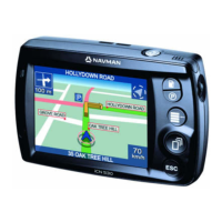
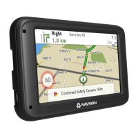
Identifies components and features of the CRUISE series device.
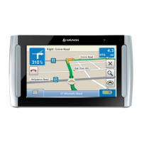
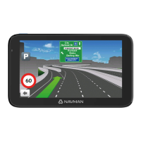
Identifies components and features of the EZY series device.
Illustrates how to mount the CRUISE series device in a vehicle.
Illustrates how to mount the MOVE series device in a vehicle.
Shows the Main Menu layout for the CRUISE series.
Shows the Main Menu layout for the EZY series.
Shows the Main Menu layout for the MOVE series.
Guides on initiating a route from the starting point to a destination.
Details how to use the FIND wizard for location searches.
Explains how to view a destination's location on the map before navigating.
Guides on previewing a calculated route in simulation mode.
Describes specialized navigation modes for large vehicles.
Explains how to choose between different route calculation options.
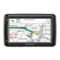
Describes the information displayed on the driving map screen.
Details how to adjust route-related settings on the Map options screen.
Explains how to access and view journey statistics.
Explains how to use zoom functions on the map display.
Describes how to check current traffic information on the route.
Introduces the Smart Routes feature for optimized routing.
Details the personalized routing feature that adapts to driving style.
Explains the automatic rerouting feature when a wrong turn is made.
Guides on how to plan a route with several waypoints.
Explains how to delete or reorder waypoints in a planned trip.
Describes how to skip a waypoint during a multi-stop trip.
Guides on saving the current GPS location.
Explains how to record and save a travel route.
Guides on navigating to previously saved locations.
Explains how to navigate back to the saved car location.
Describes how to view previously recorded travel routes.
Details how to save locations and designate a Home address.
Guides on how to navigate to locations saved in 'My Places'.
Explains how to navigate to the designated Home address.
Guides on navigating to recently visited locations.
Describes how to edit, rename, or delete saved locations.
Explains how to find nearby POIs using the 'Near Me' feature.
Guides on using the Explore map to find POIs and navigate.
Details how to find POIs displayed as clusters on the map.
Explains how to customize which POI categories are displayed.
Explains how traffic events are indicated and reported.
Describes how to view a summary of traffic situations on the map.
Guides on how to view a list of all traffic events.
Explains how to view specific details of a traffic event.
Explains how detours are recommended and displayed.
Guides on how to accept a detour to avoid a traffic event.
Lists messages displayed when a detour cannot be calculated.
Lists messages displayed when a detour is available.
Explains how to configure traffic service settings.
Details the setting to automatically re-plan routes for detours.
Guides on setting preferences for traffic event alerts.
Explains how to use the Navman as a hands-free car kit.
Guides on connecting the Navman to a Bluetooth-enabled phone.
Describes how to download and manage phone contacts.
Guides on making calls using the device's keypad.
Explains how to make calls using the downloaded contact list.
Details how to answer or reject incoming calls.
Describes options available during an active call.
Explains how to adjust volume and sound options.
Guides on changing screen brightness, mode, and touch audio.
Guides on viewing map information and managing map sets.
Explains how to change the on-screen language and voice schemes.
Guides on changing distance and time format settings.
Explains how to set the time zone manually or automatically.
Details Bluetooth pairing and compatibility information.
Describes how the Trip Meter displays trip information.
Guides on deleting saved information and restoring factory defaults.
Introduces NavDesk II as a tool for device management and updates.
Lists the minimum system requirements for installing NavDesk II.
Provides step-by-step instructions for installing NavDesk II on Windows and Mac.
Guides on connecting the Navman device to NavDesk II.
Explains how to create backups of device data for later restoration.
Details how to check for and install software and map updates.
Introduces the Contents section for managing maps and subscriptions.
Details how to set a PIN code to lock the device.
Explains the process of backing up and restoring device data.
Describes the Smart Recovery tool for fixing device issues.
Explains how to recover device keys to resolve operational problems.
Guides on changing NavDesk II language and measurement units.
Explains how GPS works and factors affecting signal reception.
Provides essential guidelines for maintaining and protecting the device.
Provides links to online support and customer service contact details.
Emphasizes the user's responsibility for adhering to speed limits.
Explains the use of safety camera alerts and user responsibility.
Categorizes saved locations and captured journeys.
Explains the icons and categories for traffic and TMC events.