9
EN
2
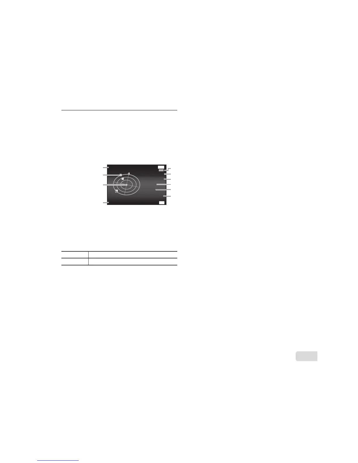
Press INFO button in the shooting
display.
Ɣ The displays change in the order of Normal ĺ
Detailed ĺ No info. ĺ Measurement position
information each time F (INFO) is pressed.
Ɣ Nearby landmarks in the GPS database will
be displayed.
OK
---------
Updated 1 min ago
2013/02/26
12:30
Latitude/Longitude
N123°56' 78''
E123°56' 78''
Barometer
877hpa
Altitude/Water Depth
1200m
LOG
MENU
Back
Update GPS
4
3
2
1
0
9
8
7
6
5
1 Landmark name
2 Landmark information
position
3 Electronic compass
4 Update status
5 GPS tracking active
6 Latitude
7 Longitude
8 Atmospheric/
Hydraulic pressure
9 Altitude/Water depth
0 Current date and
time
HI
Select a landmark.
A
Update GPS data.
Ɣ Some countries or regions may regulate the use of
GPS devices. Follow all local regulations.
Ɣ Turn GPS off when on board aircraft and in other
locations in which the use of GPS devices is
prohibited.
Ɣ The provision of A-GPS data may be terminated
without prior notice.
Ɣ Position data may be unavailable or contain errors
in the following locations:
Ɣ Locations without a clear view of the sky
(indoors, underground or underwater, or near
trees or tall buildings)
Ɣ Locations subject to strong magnetic or radio
interference (near high-voltage power lines,
magnets, electronic devices, or cell phones
operating in the 1.5 GHz band)
Ɣ GPS data may take more time acquire or be
unavailable in some locations or at certain times
of day.
Ɣ Do not cover the GPS antenna with your hands or
metal objects.
Ɣ If the battery is low, the camera cannot acquire
GPS data while the camera turns off.
Ɣ The camera is not equipped for GPS navigation.
Ɣ While [Track] is [On], the GPS receiver will
continue to draw power from the battery when the
camera is off.
Ɣ GPS data are not recorded with movies.
Ɣ Press the INFO button while the camera is turned
off. The current time and the shooting location are
displayed for approx. 30 seconds.