QK-A024/26 Manual
V 3.0 3 of 16 2020
1. Introduction
1.1. What is AIS?
The marine Automatic Identification System (AIS) is a location and vessel information reporting system.
It allows vessels equipped with AIS to automatically and dynamically share and regularly update their
position, speed, course and other information such as vessel identity with similarly equipped vessels.
Position is derived from the Global Positioning System (GPS) and communication between vessels is by
Very High Frequency (VHF) digital transmissions. There are a number of types of AIS device, like Class
A transceivers, Class B transceivers/transponders, AIS base stations, Aids to Navigation (AtoN) and AIS
receivers.
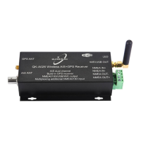
1.2. The A024/26
The A024/26 is a compact dual channel, marine AIS receiver which can receive information from both
AIS frequencies simultaneously.
A024/26 is aimed at the small-commercial, leisure, fishing boat and vessel monitoring markets.
Connected to an on-board PC running compatible software, or a chart plotter, AIS data transmitted from
ships within range will be displayed on the screen enabling the skipper or navigator to visualize the traffic
within VHF range. Using A024/26 can enhance safety at sea by providing proximity, size and directional
information from other vessels, improve safety and efficiency in navigation and help protect the marine
environment.
It also combines one external NMEA 0183 data source with the AIS and GPS (GPS-A026 only)
messages. This single data stream is then transmitted synchronously via NMEA 0183, USB and WiFi.
The A026 model includes an integrated GPS module, this provides GPS data to all outputs when it is
connected to a GPS antenna (SMA connection type).
Figure 1: A024/26 Function diagram
1.3. Products covered by this manual
 Loading...