28
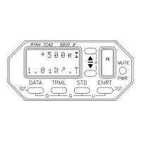
HOST ALTITUDE DISPLAY
The MSL altitude or the flight level of the host aircraft is
displayed in the search configuration. Below 18,000 feet,
the TCAD barometric correction can be adjusted to the local
altimeter setting. At 18,000 feet and above, the altimeter
automatically adjusts to 29.92 inches, and the display will
show Flight Level instead of altitude in feet.
When the local altimeter is lower than 29.92 inches, FL 180,
(and sometimes FL 190) does not exist. TCAD will not
display flight levels until the barometric correction in the
TCAD indicates that Flight Level display is appropriate.
On descent, the local altimeter setting can be preset, and
when the aircraft descends below the flight levels, the MSL
altitude will be displayed.
If the altitude features are not used, a barometric setting of
29.92 inches is recommended for the TCAD.
THREAT ALTITUDE DISPLAY
The altitude of the threat aircraft is displayed when the
DATA button is pressed. TCAD will provide the MSL
altitude of the traffic (corrected to the barometric pressure
setting in the TCAD), or the Flight Level, as appropriate.
See Section VIII, Flying with TCAD.
CAUTION: Altitude information provided by the Ryan
TCAD is advisory only and is not to be used for dispatch
purposes.
 Loading...