DISPLAY OVERVIEW
82005-PG-D SANDEL SN3500 EHSI PILOT’S GUIDE PAGE 2-5
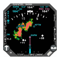
Data Color Coding
Data displayed on the SN3500 is color coded as follows:
Color Data displayed
GREEN
• Information associated with the primary VHF
NAV1 receiver (or NAV2 if in co-pilot
configuration)
• GPS annunciators: ACTV, AUTO and LEG
• Class B and C airspace
• Stormscope® data older than 30 seconds
CYAN
• Information associated with the LNAV
(GPS/FMS) receiver text
• GPS annunciators: HLD, PTK and APPR (II
Morrow GPS only)
• Map status bar icons
• Moving map icons
• Traffic range ring
• Current position symbol, either airplane or
triangle
WHITE
• Compass rose under normal conditions
• Magnetic heading and button labels
• Non-active legs and waypoints of flight plan
• To/From indicator
• Inner marker indicator
• Heading bug and associated data
• Traffic targets
• New Stormscope® data
DISPLAY OVERVIEW
82005-PG-D SANDEL SN3500 EHSI PILOT’S GUIDE PAGE 2-6
Color Data displayed
RED
• Flags indicating failed glide slope or CDI data
• Prohibited airspace
AMBER
• GPS annunciators: MSG and WPT. Also
HOLD (Garmin only)
• Compass rose when either gyro or fluxgate
has failed
• Middle marker indicator
YELLOW
• Information associated with the cross-side
NAV receiver (NAV2 if in the pilot
configuration, NAV1 if in the co-pilot
configuration)
• Restricted and warning areas
• Flag indicating invalid glide slope
• Marker test
• Decluttered map status icons
MAGENTA
• Active leg and waypoint of flight plan
• ADF bearing pointers
• Map range
BLUE
• Outer marker indicator
PURPLE
• MOA