EasyManua.ls Logo

Toyota Prius 2006 User Manual

Toyota Prius 2006
128 pages
To Next Page IconTo Next Page
Page #1 background imageLoading...
Page #1 background image
i
Introduction
Thank you for your purchase of the Navigation System. Please read this manual carefully to ensure proper use. Keep this manual
in your vehicle at all times.
The Navigation System is one of the most technologically advanced vehicle accessories ever developed. The system receives satellite
signals from the Global Positioning System (GPS) operated by the U.S. Department of Defense. Using these signals and other vehicle
sensors, the system indicates your present position and assists in locating a desired destination.
The navigation system is designed to select efficient routes from your present starting location to your destination. The system is also designed
to direct you to a destination that is unfamiliar to you in an efficient manner. The system uses DENSO maps. The calculated routes may not
be the shortest nor the least traffic congested. Your own personal local knowledge or “short cut” may at times be faster than the calculated
routes.
The navigation system’s database includes about 75 Point of Interest categories to allow you to easily select destinations such as restaurants
and banks. If a destination is not in the database, you can enter the street address or a major intersection close to it and the system will guide
you there.
The system will provide both a visual map and audio instructions. The audio instructions will announce the distance remaining and the direction
to turn in approaching an intersection. These voice instructions will help you keep your eyes on the road and are timed to provide enough
time to allow you to maneuver, change lanes or slow down.
Please be aware that all current vehicle navigation systems have certain limitations that may affect their ability to perform properly.
The accuracy of the vehicle’s position depends on the satellite condition, road configuration, vehicle condition or other circumstan-
ces. For more information on the limitations of the system, refer to pages 108 through 109.

Table of Contents

Question and Answer IconNeed help?

Do you have a question about the Toyota Prius 2006 and is the answer not in the manual?

Toyota Prius 2006 Specifications

General IconGeneral
Voice GuidanceYes
TouchscreenYes
Points of InterestYes
Display TypeLCD
Voice CommandYes
Screen Size7 inches
Traffic InformationYes (with subscription)
Map UpdatesDVD
GPS AntennaBuilt-in
Audio InputAuxiliary audio input

Summary

Introduction

BASIC FUNCTIONS

Initial screen and safety

Covers the system's startup sequence, cautionary messages, and initial safety instructions.

Touch screen operations and input

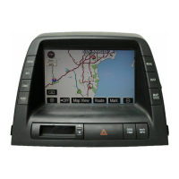
Explains touch screen interaction, input methods, and list handling.

Map display and navigation basics

Covers map orientation, current position display, screen scrolling, and map scale.

Screen modes and POI display

Details various map display modes (single, dual, compass) and how to display POI icons.

DESTINATION SEARCH & ROUTE GUIDANCE

Searching for Destinations

Guides on finding destinations by address, POI, category, memory, and emergency services.

Route Planning and Guidance

Covers setting routes, preferences, detours, adding/deleting destinations, and guidance screens.

ADVANCED FUNCTIONS

Menu, Setup, and User Management

Explains menu options, system setup, and user profile management for personalized settings.

Managing Saved Locations

Covers registering, editing, and deleting memory points, home, and areas to avoid.

Voice and Speech Control

Details voice guidance settings and using the speech command system for hands-free operation.

System Calibration and Settings

Adjusting screen brightness, position calibration, and other system configurations.

OTHER FUNCTIONS

Maintenance, Dealer, and Calendar Memos

Tracking vehicle maintenance needs, registering dealer info, and managing calendar memos.

Language and Screen Customization

Changing system language and configuring screen display options like color and auto-return.

APPENDIX

System Limitations and Map Data

Information on GPS accuracy limitations, map data sources, and update procedures.

Related product manuals