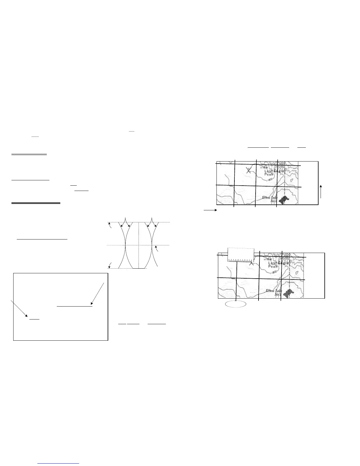
The following example uses a 1:24,000 scale, topo-map, with 1,000 meter UTM grid tick
marks, indicated by three small zeros in the easting label,
47
90
000m
E.
9.1.a -- 1:24,000 scale UTM Grid Coordinate Positioning
1. Identify and document the zone number
, map datum and scale
.
(zone 11, North American Datum 1927 & 1:24,000, Figure 27).
2. Identify UTM grid tick marks and labels around the map’s margin.
3. Draw lines connecting equal value UTM tick marks. (Fig 27)
· 1,000 meter by 1,000 meter grid will form.
4. Identify and mark a position on the map with an ‘X’.
5. Place "0" of 1:24,000 UTM scale at the ‘X’, with scale increasing left . (Fig 28)
· Make sure UTM scale is parallel to the northing grid lines.
6. Count from the ‘X’ to the nearest left easting line – 100, 200, … 500, 600 and 650 m.
7. Add 650 meter to the nearest left easting line.
· 650 m E +
5
99
000m
E =
5
99
650m
E
direction while bearings on a map are determined. With magnetic declination set at 0°, and
compass set at sighted bearing, rotate compass about position until the red lines on the graduated
dial and the blue line in the vial are aligned with the map’s true north-south lines. Then, draw
bearing lines.
8 – Back Bearing
A back bearing is 180° from another bearing. If you face true north (0° bearing) a back bearing is
directly behind you, or 180°. Keep all bearings between 0° and 360°, and follow the steps below
to determine back bearing.
Calculate back bearing:
1. If the bearing is from 0° to 180°, add 180° to calculate back bearing.
2. If the bearing is from 181° to 360°, subtract 180°.
9 – Coordinate Position
Global Positioning System (GPS) receivers are becoming valuable navigation aids with map and
compass. GPS receivers require an understanding of coordinate systems to locate a position.
This section explains positioning on a 7.5 minute topo-
graphic map, using the 1:24,000 Universal Transverse
Mercator (UTM) grid scale, on the clear base.
9.1 UTM Coordinate System
Universal Transverse Mercator (UTM) is a grid
coordinate system measured from the Equator (0°
latitude) and a zone meridian. UTM flattens and
divides the Earth into 60 zones, each zone 6° wide
and each with a zone meridian down the center.
(Fig 25) UTM grid above 84° N. and below 80° S.
latitude is considerably distorted,
and is excluded from maps.
A UTM position is measured using
an easting and a northing from a
known reference point called a
datum. If using a Global Positioning
System (GPS) receiver, document
the zone
number and map datum
(Fig 26), then enter into your GPS
receiver.
10
11
Mapped, edited, and published by the Geological Survey
Control by USGS and USC&GS
Topography by photogrammetric methods from aerial
photographs taken 1966. Field checked 1968
Polyconic projection. 1927 North American datum
10,000-foot grid based on Wyoming coordinate system,
west zone
1000-meter Universal Transverse Mercator grid ticks,
zone 12. shown in blue
Fine red dashed lines indicate selected fence lines
Where omitted, land lines have not been established