Purchase the DJI Phantom 4 RTK w/ RTK-2 Mobile Station Combo at www.tigersupplies.com.
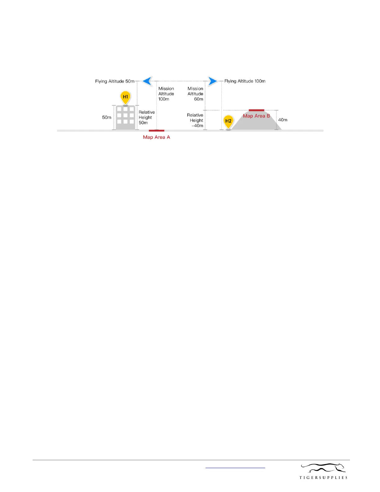
When do I need to adjust Relative Height? When the elevation of the takeoff location is
different from the elevation of the area being mapped, you can adjust the Relative Height to
ensure sufficient overlap rates in the measurement. Please see the attached illustration:
If the drone takes off from a 50m building marked H1 in the illustration, the area being
mapped is marked A, and the expected altitude for aerial data collection is 100m, you can set
the Mission Altitude in to 100m, and Relative Height to 50m. Similarly, if the drone takes off
from H2 to map Area B, which is a hill with an elevation of 40m, and the expected altitude for
aerial data collection is 60m, then set Mission Altitude to be 60m, and Relative Height to be -
40m. You can adjust Relative Height in Photogrammetry 2D, Photogrammetry 3D (Double
Grid), Photogrammetry 3D (Multi-oriented), Linear Flight Mission, and Block Segmentation
missions.
In what scenarios can variable altitude flight path missions be used? Variable altitude
flight paths are useful for taking modeling shots at belts of terrain with great altitude
differences, for instance, power transmission lines, roads and rivers with rising and falling
topography.
Are there any altitude and angle restrictions between waypoints when planning a
variable altitude flight path? There are no altitude restrictions between any two waypoints.
The actual flight altitude is determined by the altitude limit. There are no angle restrictions.
Does a variable altitude flight path mission support imported KML files? What are the
requirements for KML files? Yes. Click on the “KML” icon on the functions menu to select
the file. The KML file type must be linear, and the format of the field for absolute altitude in
the KML file must be “absolute”.
What is “mission altitude” in a variable altitude flight path mission? It is the distance
between the flight plane and the plane between Points A, B and C.
Can a flight path be executed in reverse sequence in a variable altitude flight path
mission? Yes a flight path can be executed in reverse sequence. After a flight path has been
generated from recorded waypoints, click on the reverse sequence button at the bottom of
the interface to reverse the waypoint flight sequence.
 Loading...