10
EN
Inertial Navigation System
IMU Update Frequency 200 Hz
Accelerometer Range ± 6 g
Angular Velocity Meter Range ± 300 dps
Yaw Accuracy (RMS 1σ)
[2]
Real-time: 0.2°, Post-processing: 0.05°
Pitch/Roll Accuracy (RMS 1σ)
[2]
Real-time: 0.05°, Post-processing: 0.025°
Positioning Accuracy (RTK FIX) Horizontal: 1 cm+1 ppm
Vertical: 1.5 cm+1 ppm
RGB Mapping Camera
Sensor 4/3 CMOS, 20 MP
Photo Size 5280×3956
Focal Length 24 mm (equivalent)
Shutter Speed Mechanical shutter: 1/2000-2 s
ISO Photo: 100-6400
Aperture Range f/2.8-f/11
Supported File System exFAT
Photo format JPEG/DNG (RAW)
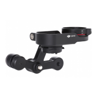
Gimbal
Stabilization System 3-axis (tilt, roll, pan)
Angular Vibration Range 0.01°
Mounting Detachable DJI SKYPORT
Controllable Rotation Range Tilt: -120° to +30°
Pan: ± 90°
Data Storage
Raw Data Storage Photo/IMU/Point cloud/GNSS/Calibration files
Supported microSD Cards microSD: Sequential writing speed of 50 MB/s or
above and a UHS-I Speed Grade 3 rating or above; Max
capacity: 256 GB
Post-Processing Software
Supported Software DJI Terra
Data Format DJI Terra supports exporting standard format point
cloud models:
Point cloud format: PNTS/LAS/PLY/PCD/S3MB
Trajectory file format: sbet.out/sbet.txt
[1] Measured using a flat target with a size larger than the laser beam diameter, perpendicular
angle of incidence, and with an atmospheric visibility of 23 km. In low-light environments,
the laser beams can achieve the optimal detection range. If a laser beam hits more than one
 Loading...