Do you have a question about the Garmin Alpha 200i and is the answer not in the manual?
Initial setup steps for the Alpha system and devices.
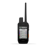
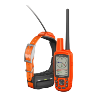
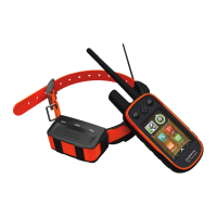
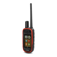
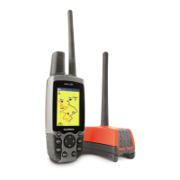
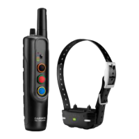
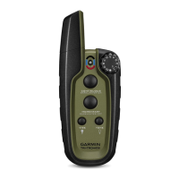
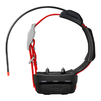
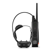
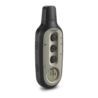
Identification and function of handheld and dog collar device components.
Procedure for installing the battery into the handheld device.
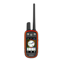
Labels and functions of the Alpha handheld device buttons.
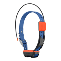
Identification of components on the dog collar device.
Steps to charge the handheld device battery.
Steps to charge the dog collar device battery.
Procedures for powering the handheld and dog collar devices on/off.
How to select language and interact with the touchscreen interface.
Accessing device status, settings, and acquiring satellite signals.
Steps to activate the inReach features and satellite subscription.
Ways to pair a dog collar with the handheld device.
Pairing a dog collar via ANT+ wireless technology.
Adding a collar using its unique track and control codes.
How to locate and share dog collar identification codes.
Creating and managing groups of dog collar devices.
Modifying dog details like name, color, type, and ID.
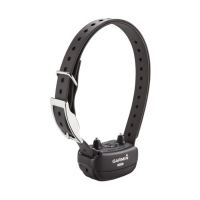
Proper placement and tightening of the collar on a dog.
Viewing dog locations and tracks on the device map.
Understanding the icons indicating a dog's current status.
Using the compass to locate dogs and other paired devices.
Following directions to reach a dog's current location.
Adjusting how long dog tracks are displayed on the map.
Creating custom geofences or radius alerts for dog locations.
Modifying or disabling existing location alerts.
Choosing and fitting collar contact points for effective training.
Overview of momentary, continuous, tone, and vibration training modes.
Determining the appropriate stimulation level for dog training.
Assigning commands and actions to device keys.
Adjusting training commands using the device's physical buttons.
Setting default training modes for new dog collar pairings.
Initial steps and advice for training a dog with the collar.
Sending pre-written messages using the inReach feature.
Composing and sending custom text messages via inReach.
Responding to received inReach messages.
Manually checking for new messages and understanding auto-checks.
Using map navigation to reach a message's origin point.
Adding current location coordinates to outgoing messages.
Removing message threads from the device.
Initiating and ending the device's tracking function.
Sharing your location and tracking data via a web link.
Steps to send an emergency SOS signal and communicate with responders.
Adding a custom message to an SOS alert.
How to cancel an active SOS request.
Obtaining basic, premium, or marine weather forecasts.
Refreshing or removing stored weather forecast data.
Verifying the satellite subscription and device functionality.
Connecting the device to a smartphone via Bluetooth.
Establishing a Wi-Fi connection for data transfer.
Using the app for trip planning, cloud storage, and map downloads.
Transferring data between the device and Garmin Explore account.
Enabling or disabling the device's transmitter for communication.
Adding other users as contacts via MURS/VHF, device ID, or wireless pairing.
Sending an immediate alert to designated contacts.
Communicating with contacts using preset or custom messages.
Saving the vehicle's position for navigation back.
Recording bird covey locations and flushing/taken counts.
Viewing real-time hunting statistics for dogs and hunts.
Activating collar features for visibility or battery conservation.
Temporarily stopping tracking for a specific dog.
Recording, storing, and managing specific geographic locations.
Saving your current position or a selected map point as a waypoint.
Modifying waypoint details and moving them on the map.
Improving waypoint location precision through averaging.
Creating new waypoints by projection and removing existing ones.
Creating, editing, and navigating sequences of waypoints.
Managing and viewing recorded track logs and activity data.
Using the map for orientation and navigating to destinations.
Calculating distances between two points on the map.
Utilizing the compass for direction and bearing.
Finding destinations using various categories in the Where To? menu.
Viewing elevation data and calibrating the barometric altimeter.
Selecting and configuring data displayed in the trip computer.
Clearing trip data to start fresh for a new journey.
Creating alerts for when dogs enter a specified radius.
Measuring the area enclosed by a defined perimeter.
Configuring and managing the device's alarm clock function.
Adjusting satellite display and disabling GPS functionality.
Setting a simulated GPS location for testing purposes.
Transferring satellite imagery to the device via Wi-Fi.
Personalizing the device's main menu and data displays.
Configuring core device parameters like language and units.
Adjusting screen brightness, timeout, appearance, and captures.
Enhancing device usability for different needs.
Customizing audible alerts for messages, keys, and dog actions.
Configuring map display options, including tracked devices and data fields.
Adjusting track recording, route calculation, and sensor pairing.
Customizing measurement units and coordinate system settings.
Accessing electronic regulatory and compliance information.
Obtaining software, map updates, and product registration.
Procedures for safely cleaning the device and its screen.
Technical details for the handheld and TT 15 dog collar devices.
Details on battery types, life, and operating conditions.
Tips to extend battery performance for the device and collar.
Customizing units for distance, speed, elevation, and temperature.
Setting position format, map datum, and map spheroid.
Guidelines for storing devices for extended periods to preserve battery.
Steps to minimize power consumption during charging.
Information on using memory cards for storage.
Procedure for inserting a microSD card into the device.
Linking the handheld and collar devices to a computer.
Moving recorded dog track data to BaseCamp software.
Safely removing files and disconnecting the device from a computer.
Restoring device settings to factory defaults or deleting user data.
Information on purchasing optional accessories and replacement components.
Identification of parts for TT 15 collar battery replacement.
Step-by-step guide for replacing the battery in the TT 15 collar.
Detailed instructions for battery replacement in the TT 15 mini collar.
Steps for removing and attaching a new collar strap.
Guide for replacing the VHF antenna on the dog collar device.
Procedure for replacing the fuse in the vehicle power adapter.
Explanations for various data fields displayed on the device.
| Display Resolution | 282 x 470 pixels |
|---|---|
| Water Rating | IPX7 |
| Preloaded Maps | Yes |
| Dog Tracking | Yes |
| High-sensitivity Receiver | Yes |
| Interface | USB |
| Memory/History | 16 GB |
| Ability to Add Maps | Yes |
| Waypoints/Favorites/Locations | 10, 000 |
| Tracks | Yes |
| Routes | 250 |
| inReach Features | Yes |
| Display Size | 3.5" |
| Wireless Connectivity | Wi-Fi, Bluetooth, ANT+ |
| Physical Dimensions | 2.7" x 6.4" x 1.3" (6.8 x 16.2 x 3.4 cm) |
| Display Type | Transflective color TFT touchscreen |
| Battery Type | Rechargeable lithium-ion |
| Accepts Data Cards | Yes (microSD card, not included) |
| Track Log | 20, 000 points |
| Tracking Range | 9 miles |
| Device Type | Handheld |
| Compatibility | Compatible with Garmin Explore™ app |
| Battery Life | Up to 20 hours (Dog tracking with inReach technology enabled); Up to 15 hours (Dog tracking with inReach technology and 10 second tracking) |